Villers-Brûlin
| Villers-Brûlin | ||
|---|---|---|

|
|
|
| region | Hauts-de-France | |
| Department | Pas-de-Calais | |
| Arrondissement | Arras | |
| Canton | Avesnes-le-Comte | |
| Community association | Campagnes de l'Artois | |
| Coordinates | 50 ° 22 ′ N , 2 ° 32 ′ E | |
| height | 110-153 m | |
| surface | 3.81 km 2 | |
| Residents | 365 (January 1, 2017) | |
| Population density | 96 inhabitants / km 2 | |
| Post Code | 62690 | |
| INSEE code | 62856 | |
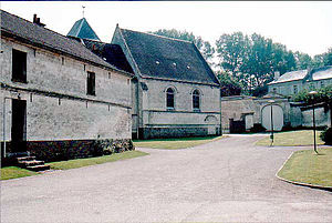
 Center of Villers-Brûlin |
||
Villers-Brûlin is a commune of 365 inhabitants (at January 1, 2017) in the department of Pas-de-Calais in the region of Hauts-de-France . It belongs to the Arrondissement of Arras and the canton of Avesnes-le-Comte (until 2015: canton of Aubigny-en-Artois ).
geography
Villers-Brûlin is located in northern France . North of the municipality is Frévillers , northeast Béthonsart , southeast Savy-Berlette , south Berles-Monchel , southwest Tincques and northwest Chelers .
Population development
| year | 1962 | 1968 | 1975 | 1982 | 1990 | 1999 | 2008 | 2013 |
|---|---|---|---|---|---|---|---|---|
| Residents | 280 | 289 | 270 | 278 | 315 | 300 | 313 | 298 |
Web links
Commons : Villers-Brûlin - collection of images, videos and audio files
