
Étrun
| Étrun | ||
|---|---|---|

|
|
|
| region | Hauts-de-France | |
| Department | Pas-de-Calais | |
| Arrondissement | Arras | |
| Canton | Arras-1 | |
| Community association | Arras | |
| Coordinates | 50 ° 19 ′ N , 2 ° 42 ′ E | |
| height | 58-107 m | |
| surface | 2.22 km 2 | |
| Residents | 314 (January 1, 2017) | |
| Population density | 141 inhabitants / km 2 | |
| Post Code | 62161 | |
| INSEE code | 62320 | |
| Website | http://www.etrun.fr/ | |

Étrun ( Flemish : Stroom ) is a French municipality with 314 inhabitants (as of January 1 2017) in the department of Pas-de-Calais in the region of Hauts-de-France . The municipality belongs to the Arrondissement Arras and the canton Arras-1 (until 2015: Canton Dainville ). The inhabitants are called Strumensiens .
geography
Étrun is about six kilometers west-northwest of the city center of Arras am Gy . Étrun is surrounded by the neighboring communities of Marœuil in the north and east, Duisans in the south, Agnez-lès-Duisans in the west and south-west and Haute-Avesnes in the north-west.
Population development
| year | 1962 | 1968 | 1975 | 1982 | 1990 | 1999 | 2006 | 2013 |
|---|---|---|---|---|---|---|---|---|
| Residents | 378 | 414 | 367 | 302 | 336 | 326 | 329 | 325 |
| Source: Cassini and INSEE | ||||||||
Attractions
- Saint-Nicolas church
- Notre-Dame-de-Pitié chapel

Saint-Nicolas church
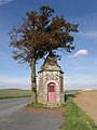
Notre-Dame-de-Pitié chapel


Web links
Commons : Étrun - collection of images, videos and audio files