Corbehem
| Corbehem | ||
|---|---|---|

|
|
|
| region | Hauts-de-France | |
| Department | Pas-de-Calais | |
| Arrondissement | Arras | |
| Canton | Brebières | |
| Community association | Osartis Marquion | |
| Coordinates | 50 ° 20 ′ N , 3 ° 4 ′ E | |
| height | 28-36 m | |
| surface | 2.6 km 2 | |
| Residents | 2,366 (January 1, 2017) | |
| Population density | 910 inhabitants / km 2 | |
| Post Code | 62112 | |
| INSEE code | 62240 | |
| Website | http://www.corbehem.fr/ | |
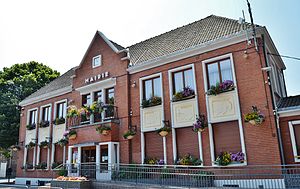
 Corbehem Town Hall |
||
Corbehem ( Flemish : Corbeham ) is a French municipality with 2366 inhabitants (as of January 1 2017) in the department of Pas-de-Calais in the region of Hauts-de-France . It belongs to the Arrondissement of Arras and the canton of Brebières (until 2015: canton of Vitry-en-Artois ).
geography
Corbehem lies on the canalised Scarpe . The Canal de la Sensée forms the northeastern municipal boundary. Corbehem is surrounded by the neighboring municipalities of Lambres-lez-Douai in the north, Courchelettes in the east and northeast, Férin in the southeast, Gouy-sous-Bellonne in the south and Brebières in the west.
The Corbehem station is on the Paris – Lille line .
Population development
| year | 1962 | 1968 | 1975 | 1982 | 1990 | 1999 | 2006 | 2011 |
| Residents | 1,870 | 2,094 | 2,611 | 2,368 | 2,346 | 2,318 | 2.224 | 2,298 |
Attractions
- Notre-Dame church, rebuilt after 1918
- Water tower
- British military cemetery
folklore
The giant figure Jean de Corbehem , recognizable as a knight in armor with a shield, is part of local folklore.

