
Flers (Pas-de-Calais)
| Flers | ||
|---|---|---|

|
|
|
| region | Hauts-de-France | |
| Department | Pas-de-Calais | |
| Arrondissement | Arras | |
| Canton | Saint-Pol-sur-Ternoise | |
| Community association | Ternois | |
| Coordinates | 50 ° 19 ′ N , 2 ° 15 ′ E | |
| height | 78-143 m | |
| surface | 5.5 km 2 | |
| Residents | 225 (January 1, 2017) | |
| Population density | 41 inhabitants / km 2 | |
| Post Code | 62270 | |
| INSEE code | 62337 | |

Flers is a commune in the French Pas-de-Calais in the region of Hauts-de-France . It belongs to the canton of Saint-Pol-sur-Ternoise in the Arrondissement of Arras . Neighboring municipalities are Héricourt in the north, Croisette and Hautecloque in the northeast, Écoivres in the east, Nuncq-Hautecôte in the southeast, Boubers-sur-Canche in the south, Monchel-sur-Canche in the southwest and Blangerval-Blangermont in the west.
Population development
| year | 1962 | 1968 | 1975 | 1982 | 1990 | 1999 | 2008 | 2013 |
|---|---|---|---|---|---|---|---|---|
| Residents | 237 | 250 | 228 | 227 | 221 | 200 | 185 | 215 |
Attractions
- Castle, Monument historique
- Saint-Éloi Church, Monument historique
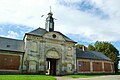
Castle of Flers
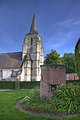
Saint-Éloi church


Web links
Commons : Flers - collection of images, videos and audio files