
Tilloy-lès-Mofflaines
| Tilloy-lès-Mofflaines | ||
|---|---|---|

|
|
|
| region | Hauts-de-France | |
| Department | Pas-de-Calais | |
| Arrondissement | Arras | |
| Canton | Arras-3 | |
| Community association | Arras | |
| Coordinates | 50 ° 17 ′ N , 2 ° 49 ′ E | |
| height | 54-102 m | |
| surface | 7.69 km 2 | |
| Residents | 1,434 (January 1, 2017) | |
| Population density | 186 inhabitants / km 2 | |
| Post Code | 62217 | |
| INSEE code | 62817 | |
 Town hall (Mairie) of Tilloy-lès-Mofflaines |
||

Tilloy-les-Mofflaines is a French commune with 1,434 inhabitants (as of January 1 2017) in the department of Pas-de-Calais in the region of Hauts-de-France . The municipality belongs to the Arrondissement Arras and Arras-3 (until 2015: Canton Arras-Sud ). The inhabitants are called Tilloysia .
geography
Tilloy-lès-Mofflaines is three kilometers southwest of Arras city center . Tilloy-lès-Mofflaines is surrounded by the neighboring communities of Saint-Laurent-Blangy in the north, Feuchy in the east and northeast, Wancourt in the south and southeast, Neuville-Vitasse in the south, Beaurains in the southwest and Arras in the west and northwest.
Population development
| year | 1962 | 1968 | 1975 | 1982 | 1990 | 1999 | 2008 | 2013 |
|---|---|---|---|---|---|---|---|---|
| Residents | 679 | 773 | 744 | 806 | 1,309 | 1,329 | 1,398 | 1,449 |
| Source: Cassini and INSEE | ||||||||
Attractions
- Saint-Brice church, rebuilt after the First World War
- René-Lefrère park and castle
- British military cemetery
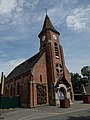
Saint-Brice church

René-Lefrère Park


Web links
Commons : Tilloy-lès-Mofflaines - Collection of images, videos and audio files