
Villers-lès-Cagnicourt
| Villers-lès-Cagnicourt | ||
|---|---|---|

|
|
|
| region | Hauts-de-France | |
| Department | Pas-de-Calais | |
| Arrondissement | Arras | |
| Canton | Brebières | |
| Community association | Osartis Marquion | |
| Coordinates | 50 ° 13 ' N , 3 ° 1' E | |
| height | 47-79 m | |
| surface | 4.4 km 2 | |
| Residents | 264 (January 1, 2017) | |
| Population density | 60 inhabitants / km 2 | |
| Post Code | 62182 | |
| INSEE code | 62858 | |

Villers-lès-Cagnicourt is a French municipality with 264 inhabitants (at January 1, 2017) in the department of Pas-de-Calais in the region of Hauts-de-France . It belongs to the Arrondissement of Arras and the canton of Brebières .
Neighboring municipalities of Villers-lès-Cagnicourt are Dury in the north, Saudemont in the northeast, Baralle in the east, Buissy in the southeast, Cagnicourt in the southwest, and Haucourt in the northwest.
Population development
| year | 1962 | 1968 | 1975 | 1982 | 1990 | 1999 | 2007 |
| Residents | 245 | 224 | 225 | 207 | 201 | 212 | 230 |
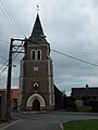
Saint Martin Church


Web links
Commons : Villers-lès-Cagnicourt - Collection of images, videos and audio files