
Glénat
|
Glénat Glenat |
||
|---|---|---|

|
|
|
| region | Auvergne-Rhône-Alpes | |
| Department | Cantal | |
| Arrondissement | Aurillac | |
| Canton | Saint-Paul-des-Landes | |
| Community association | Châtaigneraie Cantalienne | |
| Coordinates | 44 ° 54 ' N , 2 ° 11' E | |
| height | 534-747 m | |
| surface | 24.27 km 2 | |
| Residents | 174 (January 1, 2017) | |
| Population density | 7 inhabitants / km 2 | |
| Post Code | 15150 | |
| INSEE code | 15076 | |
| Website | http://www.glenat15.fr/ | |
.JPG) Town hall (Mairie) of Glénat |
||

Glénat ( Occitan Glenat ) is a French municipality with 174 inhabitants (at January 1, 2017) in the department of Cantal in the region of Auvergne Rhône-Alpes (before 2016 Auvergne ). It belongs to the arrondissement of Aurillac and the canton of Saint-Paul-des-Landes (until 2015 Laroquebrou ).
location
Glénat is located about eighteen kilometers west of Aurillac in the Massif Central in the Châtaigneraie natural landscape . Glénat is surrounded by the neighboring communities of Siran in the north and north-west, Saint-Gérons in the north and north-east, Le Rouget-Pers in the east and south-east, La Ségalassière in the east, Roumégoux in the south and south-east and Saint-Saury in the west and south-west.
Population development
| year | 1962 | 1968 | 1975 | 1982 | 1990 | 1999 | 2006 | 2011 | 2016 |
| Residents | 421 | 371 | 298 | 302 | 271 | 223 | 218 | 204 | 177 |
| Source: Cassini and INSEE | |||||||||
Attractions
- Saint Blaise Church
- La Grillère Castle, originally from the 13th century, today's building from the 17th century, a historic monument since 1987
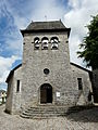
Saint Blaise Church

La Grillère Castle

.JPG)