
Oberstenfeld
| coat of arms | Germany map | |
|---|---|---|

|
Coordinates: 49 ° 1 ' N , 9 ° 19' E |
|
| Basic data | ||
| State : | Baden-Württemberg | |
| Administrative region : | Stuttgart | |
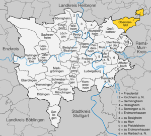
| County : | Ludwigsburg | |
| Height : | 246 m above sea level NHN | |
| Area : | 21.1 km 2 | |
| Residents: | 8027 (December 31, 2018) | |
| Population density : | 380 inhabitants per km 2 | |
| Postal code : | 71720 | |
| Primaries : | 07062, 07194 | |
| License plate : | LB, VAI | |
| Community key : | 08 1 18 060 | |
| LOCODE : | DE OFD | |
| Community structure: | 3 districts | |
| Address of the municipal administration: |
Großbottwarer Strasse 20 71720 Oberstenfeld |
|
| Website : | ||
| Mayor : | Markus Kleemann ( CDU ) | |
| Location of the municipality of Oberstenfeld in the Ludwigsburg district | ||
  |
||

Oberstenfeld [ ˈoːbɐstn̩fɛlt ] is a municipality in the Ludwigsburg district in Baden-Württemberg , 40 km north of Stuttgart . It belongs to the Stuttgart region and the peripheral zone of the European metropolitan region of Stuttgart .
geography
Geographical location
Oberstenfeld is located in the upper Bottwartal in the northeast of the Ludwigsburg district and is part of the natural areas of the Swabian-Franconian Forest Mountains and the Neckar Basin . In the north and east it is bordered by the Löwenstein Mountains , to the west the hills of Forstberg and Wunnenstein, covered by vineyards, rise up. The suburb Prevorst is located on the forest heights of the Löwensteiner Mountains in a community exclave, surrounded by the areas of four communities in the Heilbronn and Rems-Murr districts .
Neighboring communities
The closest neighboring communities are Beilstein in the north and Großbottwar in the south.
Community structure
Oberstenfeld consists of the three districts ( residential districts ) Gronau ( residential district II ), Prevorst ( residential district III ) and Oberstenfeld ( residential district I ). The districts are officially named by prefixing the name of the municipality and followed by the names of the districts connected with a hyphen. The three districts form residential districts within the meaning of the Baden-Württemberg municipal code and the two districts Gronau and Prevorst together form a locality within the meaning of the Baden-Württemberg municipal code with its own local council and mayor as its chairman. For the election of the local council, the false choice of suburbs is used accordingly, Gronau and Prevorst form the two residential districts, residential district II and residential district III . The districts of Gronau and Prevorst formed the independent municipality of Gronau until December 31, 1971. The village of Gronau belongs to the district of Gronau. The hamlet of Prevorst belongs to the district of Prevorst. The Oberstenfeld district includes the village of Oberstenfeld, Lichtenberg Castle and Homestead and the Neuwirtshaus residential area, as well as the abandoned villages of Glashausen , Kratzheim, Schmaleneck and Zum Hag.
Gronau is located immediately northeast of Oberstenfeld, Prevorst is about five kilometers northeast of Oberstenfeld in the Löwenstein Mountains. Prevorst is separated from the rest of the municipality and forms an exclave between the Heilbronn district and the Rems-Murr district . At 483 meters above sea level, it is the highest place in the Ludwigsburg district.
Division of space

According to data from the State Statistical Office , as of 2014.
history

History of Oberstenfeld
Oberstenfeld originated in the 7th or 8th century. It was settled by the pre-existing village of Boteburon, now Großbottwar. In 1016, the Oberstenfeld women's monastery was founded on site . In 1357 the Counts of Württemberg took over its patronage. The monastery, which accepted the Reformation in 1540, remained part of the imperial knighthood until 1803 and was only then taken over by Württemberg.
During the Thirty Years' War , the place, like all surrounding places, suffered greatly. In the summer of 1693, Oberstenfeld, like the neighboring Beilstein, was set on fire by French troops in the Palatinate War of Succession , with around a third of the town, including the town hall, being burned down.
With the new administrative structure of the young Kingdom of Württemberg , Oberstenfeld came to the Oberamt Marbach in 1807 . In 1832 the place had about 1200 inhabitants. Since there was initially no settlement of industrial companies in the course of industrialization, there was almost no growth in the 19th century in the place adjoining the monastery grounds to the northeast and stretching along Marktstrasse and Schmiedbergstrasse. It was not until 1900 that the Bottwartalbahn was built that important economic aspects emerged, but growth was rather modest until immediately after the Second World War. During the administrative reform during the Nazi era in Württemberg , Oberstenfeld came to the Ludwigsburg district in 1938.
In 1945 the place became part of the American zone of occupation and thus belonged to the newly founded state of Württemberg-Baden , which was incorporated into the current state of Baden-Württemberg in 1952. In 1953, 1780 inhabitants were counted in Oberstenfeld. The designation of construction and industrial areas brought industrial companies and residents to the area. The most important industrial companies included a Getrag plant and the Werzalit company . In addition, other industrial companies developed from regional craft businesses. In 1968 about 3000 inhabitants were counted. The town center received its present form through several area renovations from the 1970s. In 1972 Gronau and Prevorst were incorporated, making the community a population of over 7,000.
History of the districts
The district of Prevorst [ ˈpreːfɔrst ] and Lichtenberg Castle also came from the Lords of Lichtenberg to the Counts of Württemberg in 1357, who had already acquired Gronau from the Margraves of Baden a few years earlier (1350) . Prevorst subsequently belonged to the municipality of Gronau.
While the three places were still jointly assigned to the Marbach Oberamt from 1810 , Oberstenfeld came to the Ludwigsburg district in 1938 , while Gronau and Prevorst went to the Heilbronn district . On January 1, 1972, Gronau was incorporated with Prevorst, however, changing the district to Oberstenfeld.
The place Prevorst was born by Friederike Hauffe . Wanner (1801–1829), the so-called seeress of Prevorst , known about whom Justinus Kerner wrote a report.
Population development
Population figures according to the respective area. The numbers are census results (¹) or official updates from the Baden-Württemberg State Statistical Office (only main residences ).
|
|
Religions
Since the Reformation ordered by Duke Ulrich in 1534 , the communities in Oberstenfeld have been evangelical. There are three Protestant congregations with their respective houses of worship. The Cyriakuskirche is in Gronau, the collegiate church of St. John the Baptist in Oberstenfeld and the Protestant church, which was only built in 1905, in Prevost. These three parishes belong to the Marbach church district of the Evangelical Church in Württemberg .
After the Second World War, a Catholic parish was formed with the Church of the Holy Heart of Jesus, which was built in 1962 . The community belongs to the Bottwartal pastoral care unit in the Ludwigsburg dean's office in the Rottenburg-Stuttgart diocese .
There is also a New Apostolic church and a mosque in Oberstenfeld . The mosque is called Selimiye Camii and is operated by the DITIB .
politics

Municipal council
In Oberstenfeld, the municipal council is elected using the spurious sub-district election. The number of local councils can change due to overhang mandates . The municipal council in Oberstenfeld has 19 members after the last election (previously: 18). The local election on May 26, 2019 led to the following result: The local council consists of the elected honorary councilors and the mayor as chairman. The mayor is entitled to vote in the municipal council.
| Parties and constituencies |
% 2019 |
Seats 2019 |
% 2014 |
Seats 2014 |
||
| FW | Free voters Oberstenfeld | 40.68 | 8th | 39.41 | 7th | |
| CDU | Christian Democratic Union of Germany | 35.27 | 7th | 34.58 | 6th | |
| SPD | Social Democratic Party of Germany | 24.05 | 4th | 26.01 | 5 | |
| total | 100.0 | 19th | 100.0 | 18th | ||
| voter turnout | 65.99% | 55.41% | ||||
mayor


In May 2015, Markus Kleemann was elected in the second ballot to succeed Reinhard Rosner, who held the office of mayor for 24 years. Before Rosner, Manfred Läpple held the office for 38 years.
badges and flags
The coat of arms of the community shows: In silver on green ground a black, silver-lined horse bursting into the air, on which sits a black armored rider (a colonel) with a red plume and a silver sword. The coat of arms goes back to a seal used since 1681 and symbolizes the place name.
The municipal flag is green and white and was used before 1935.
.png)
The coat of arms of the district of Gronau shows a green oak in silver on green ground, the trunk of which is accompanied by two red roses. The coat of arms and a green and white flag were awarded to the then municipality of Gronau on March 30, 1960.
Town twinning
Since September 2005 there has been an official partnership with the small Italian town Verbicaro in the province of Cosenza . Many Italian citizens in Oberstenfeld originally come from this 3000-strong small town in Calabria . A sign at the entrance to the town honors this town twinning.
Culture and sights
Oberstenfeld is located on the Württemberg Wine Route , which leads past many sights.
Buildings

Lichtenberg Castle towers above Oberstenfeld amid idyllic vineyards.
The Romanesque St. Peter's Church with the choir tower , located on a ridge about a kilometer north of today's town center, is the legacy of a no longer existing predecessor parish. In pagan times there was very likely a place of sacrifice at the place until the place was converted for Christian worship. In the first half of the 11th century, the original wooden church was replaced by the current stone church. In the 13th century the choir was vaulted and the church was completely painted with frescoes, some of which are still preserved. The church was almost forgotten and remained unused for a long time. 1973–1976, however, it was restored and has since been used for Protestant and occasionally for Catholic services. The Peterskirche is one of the oldest sacred buildings in Württemberg.
The second oldest church in the community, the Cyriakuskirche , is located in the district of Gronau. Your choir tower dates from the 13th and 14th centuries. In 1599 it was rebuilt and expanded. Inside there is a beautiful sermon pulpit with an equally beautiful staircase.

Collegiate Church of St. John the Baptist

Peterskirche, fresco from the 13th century

Cyriakus Church in Gronau

Fleckenkirche in Oberstenfeld

Peterskirche


The Protestant collegiate church of St. John the Baptist in the center of the village is one of the most important Romanesque churches in the country. It was built as a place of prayer for the aristocratic women's choir founded in 1016. The oldest part is the western half of the crypt from the late 11th century. The former building was then replaced. First came the main nave, which was built around 1220 and then the choir tower at 1230. It is open from May to October on Sundays from 11 am to 1 pm. Guided tours are offered for a fee. Right next to it is the village church , built in the 9th century as the Gallus chapel. Later it became the prayer house of the Fleckengemeinde in contrast to the neighboring collegiate church, which was reserved for the noble canons. After severe damage from 1693, it was rebuilt in 1738. The north portal is adorned by the stone coat of arms of the community, a mounted colonel who is also present on the weather vane .
The youngest church in Oberstenfeld is the Evangelical Church in the Prevorst district, which was built in 1905 in a neo-Gothic style.
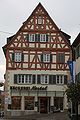
A number of well-restored baroque half-timbered houses have been preserved in the town center, including
- the town hall , which was initially built in 1698 as a single storey and to which two more storeys were added in 1840;
- the half-timbered house at Großbottwarer Straße 14, across the corner from the town hall on the market square, built in 1700;
- the bakery, the former benefice house from 1702, birthplace of the democrat Johannes Nefflen , originally a residence for the canons;
- the winegrower's house at Berggasse 2, built in 1737;
- the cooper's house from 1726 at Küfergasse 15.
Former beneficiary

Winery Berggasse 2

Historic train station in Oberstenfeld

Half-timbered house in Küfergasse


The old station of the Bottwartalbahn is just a few minutes' walk south of the old town center . The Royal Württemberg State Railways built the station building in 1893 as a type IIa unit station .
The war memorial for the fallen of the First World War was created by the Nuremberg sculptor Wilhelm Krauss and inaugurated in 1923.
Sports
- The sports and cultural association SKV Oberstenfeld offers handball , judo , aikido , a coronary sports group , gymnastics , spinal gymnastics , fitness gymnastics , volleyball and badminton .
- The Oberstenfeld tennis club maintains ten outdoor courts and three indoor courts for its members.
- The DLRG Oberes Bottwartal offers swimming / lifeguard training in the mineral open-air pool in Upper Bottwartal and in the Beilstein indoor pool .
- The TSV Gronau offers, among other things, a handball, a shooting and a mountain sports department.
- FV Oberstenfeld is a pure football club and currently plays in the district league A.
- The soap carriage and ski club SSV Prevorst offers gymnastics and gymnastics for kindergarten and elementary school children, mountain bike trips for young people and adults, dance circles (disco fox, as well as standard and latin) and gymnastics and leisure sports groups.
Regular events
The Whitsun tournament of SKV Oberstenfeld attracts handball players from the surrounding area and foreign clubs every year.
The Bottwartal Marathon , which is held every year, also leads through Oberstenfeld, and since 2012 the half marathon has started in the Gronau district.

The Fleckenfest in Oberstenfeld is organized annually on the last weekend in June by the local associations.

useful information
In the fall of 2001 , the filming of the film The Desire , directed by Iain Dilthey, took place in the Prevorst district .
Economy and Infrastructure
Oberstenfeld is a wine-growing place whose locations belong to the major area of Wunnenstein in the Württemberg lowlands of the Württemberg wine-growing region . The W&W seminar and conference center of the financial services group Wüstenrot & Württembergische is located in the suburb of Gronau .
traffic
The nearby A 81 Stuttgart - Würzburg ensures very good transport connections by car in all directions. Since Oberstenfeld is still part of the Stuttgart Transport Association (VVS), there is a good connection to public transport in the direction of Marbach am Neckar by bus, where you can change to the S-Bahn to Stuttgart .
From 1894 to 1968 Oberstenfeld was connected to the railway network via the narrow-gauge Bottwartalbahn , the narrow-gauge line from Marbach am Neckar to Heilbronn Süd . After dismantling the tracks, the old route is now partially used for the Alb-Neckar cycle path .
Established businesses
Oberstenfeld has a number of medium-sized companies and also larger employers such as Werzalit or Hoerbiger. Since 2010, the production of the medical technology manufacturer Novalung GmbH has been in Oberstenfeld. The Kreissparkasse Ludwigsburg operates a branch in Oberstenfeld, which is part of the Marbach regional office.

Public facilities
There is a retirement and nursing home of the district's own shamrock nursing homes .
The Upper Bottwartal mineral swimming pool is operated in cooperation with the neighboring community of Beilstein and is open from the beginning of May to mid-September. There are over 1000 parking spaces available.

The GroMusle is housed in the former town hall in the Gronau district. In this museum, run by volunteers, objects from recent history from the community and the region are presented in permanent and temporary exhibitions.
In the historical station there is a local history collection, which presents important objects from the local history and from the historical house and agriculture. This also includes a completely preserved Schumacher workshop from around 1930.
education
The Lichtenbergschule in Oberstenfeld is a primary and secondary school with a technical secondary school . There are also 4 day care centers in Oberstenfeld and one each in the two districts of Gronau and Prevorst.
Supply and disposal
The electricity network and the natural gas network in the community are operated by Syna GmbH, a subsidiary of Süwag Energie AG.
The western part of Oberstenfeld is supplied with external water from the state water supply, the eastern part of Oberstenfeld with mixed water from own water and state water. The districts of Gronau and Prevorst are supplied with their own water.
The waste is taken from the Abfallverwertungsgesellschaft the district Ludwigsburg mbH (AVL), a 100% subsidiary of the district Ludwigsburg. AVL is commissioned to carry out the tasks of avoiding, recycling and disposing of waste on behalf of the Ludwigsburg district.
Sons and daughters of the church
- Jonathan Friedrich Bahnmaier (1774–1841), theologian and hymn poet
- Christian Friedrich Traugott Duttenhofer (1778–1846), born in Gronau, engraver
- Johannes Nefflen (1789-1858), mayor of Pleidelsheim and democratic member of the state parliament
- Friederike Hauffe (1801–1829), born in Prevorst, the "Seer of Prevorst"
- Albert Pantle (1859–1921), architect
- Hermann Helber (1902–1945), long distance and obstacle runner from Gronau
- Eugen Bertsch (1907–1980), marathon runner from Gronau
- Egon Flaig (* 1949), ancient historian and critic of Islam
- Bernd Umbreit (* 1950), filmmaker
People in connection with Oberstenfeld
- Albert Kallee (1884–1956), district court director in Stuttgart, spent the post-war period at the Neuwirtshaus
People in connection with the community
- Albert Kallee (1884–1956), district court director in Stuttgart, spent part of the war years and the post-war period on the Neuwirtshaus residential area
literature
- The Ludwigsburg district , ed. by Ulrich Hartmann. 2nd edition, Konrad Theiss Verlag, Stuttgart, 1994.
- Oberstenfeld - Gronau - Prevorst in history and stories . Geiger, Horb am Neckar 1989.
- Oberstenfeld - Gronau - Prevorst in history and stories. Volume 2 . Geiger, Horb am Neckar 1993, ISBN 3-89264-882-4 .
- Oberstenfeld - Gronau - Prevorst in history and stories. Volume 3 . Geiger, Horb am Neckar 1998, ISBN 3-89570-441-5 .
Web links
Individual evidence
- ↑ State Statistical Office Baden-Württemberg - Population by nationality and gender on December 31, 2018 (CSV file) ( help on this ).
- ↑ Natural areas of Baden-Württemberg . State Institute for the Environment, Measurements and Nature Conservation Baden-Württemberg, Stuttgart 2009
- ^ The state of Baden-Württemberg. Official description by district and municipality. Volume III: Stuttgart District, Middle Neckar Regional Association. Kohlhammer, Stuttgart 1978, ISBN 3-17-004758-2 . Pp. 440-442
- ↑ Main statute of the municipality of Oberstenfeld from September 20, 2001, last changed on January 25, 2007 ( page no longer available , search in web archives ) Info: The link was automatically marked as defective. Please check the link according to the instructions and then remove this notice. (PDF; 51 kB)
- ↑ State Statistical Office, area since 1988 according to actual use for Oberstenfeld.
- ↑ Population development in Baden-Württemberg from 1871 to 2012 ( page no longer available , search in web archives ) Info: The link was automatically marked as defective. Please check the link according to the instructions and then remove this notice.
- ↑ Election information for the municipal data center
- ↑ http://www.marbacher-zeitung.de/inhalt.oberstenfeld-markus-kleemann-macht-das-rennen.ae4a5287-ca69-46f3-9c79-22de183241fe.html
- ↑ a b c d e citizen information brochure. Municipality of Oberstenfeld, December 2018, accessed on April 20, 2020 .
- ^ Rainer Stein: The Württemberg standard station on branch lines . In: Eisenbahn-Journal Württemberg-Report . tape 1 , no. V / 96 . Merker, Fürstenfeldbruck 1996, ISBN 3-922404-96-0 , p. 80-83 .
- ↑ SSV Prevorst - Seifenkutschen- und Skiverein Prevorst EV Accessed on May 14, 2020 (German).
- ↑ Overview of the regional offices of the Kreissparkasse Ludwigsburg ( Memento from April 12, 2013 in the web archive archive.today )
- ↑ BDEW (Ed.): Map of the electricity network operator 2012. Frankfurt 2012.
- ↑ BDEW (Ed.): Map of the gas network operators 2012. Frankfurt 2012.
- ↑ Water supply for the municipality of Oberstenfeld: supply areas. Oberstenfeld 2009.

Affalterbach | Asperg | Benningen am Neckar | Besigheim | Bietigheim-Bissingen | Bönnigheim | Ditzingen | Eberdingen | Erdmannhausen | Erligheim | Freiberg am Neckar | Freudental | Gemmrigheim | Gerlingen | Grossbottwar | Hemmingen | Hessigheim | Ingersheim | Kirchheim am Neckar | Korntal-Münchingen | Kornwestheim | Löchgau | Ludwigsburg | Marbach am Neckar | Markgröningen | Möglingen | Mundelsheim | Murr | Oberriexingen | Oberstenfeld | Pleidelsheim | Remseck am Neckar | Sachsenheim | Schwieberdingen | Sersheim | Steinheim an der Murr | Tamm | Vaihingen an der Enz | Walheim