
Horní Lapač
| Horní Lapač | |||||
|---|---|---|---|---|---|
|
|||||
| Basic data | |||||
| State : |
|
||||
| Region : | Zlínský kraj | ||||
| District : | Kroměříž | ||||
| Area : | 76 ha | ||||
| Geographic location : | 49 ° 18 ' N , 17 ° 37' E | ||||
| Height: | 262 m nm | ||||
| Residents : | 272 (Jan. 1, 2019) | ||||
| Postal code : | 769 01 | ||||
| License plate : | Z | ||||
| traffic | |||||
| Street: | Holešov - Fryšták | ||||
| structure | |||||
| Status: | local community | ||||
| Districts: | 1 | ||||
| administration | |||||
| Mayor : | František Kolečík (as of 2010) | ||||
| Address: | Horní Lapač 22 769 01 Holešov |
||||
| Municipality number: | 588474 | ||||
| Website : | www.hornilapac.cz | ||||


Horní Lapač (German Ober Lapatsch ) is a municipality in the Czech Republic . It is located five kilometers southeast of Holešov and belongs to the Okres Kroměříž .
geography
Horní Lapač is located at the foot of the Hostýnské vrchy in the southeast of the Upper Moravian Basin ( Hornomoravský úval ) at the transition to the Fryštácká brázda ( Free Town Basin ). The Žeranovka brook, which rises north of Horní Lapač, flows through the village. To the northeast rise the Hrádek (502 m), Hrad (560 m), Chochol (578 m) and the Hrubá Malíková (564 m) and in the south the Hrádek (281 m). The R 49 expressway is being built south of the village .
Neighboring towns are Přílepy in the north, Hadovna and Rusava in the northeast, Lukoveček and Horní Ves in the east, Sovárna, Žabárna and Kučovanice in the southeast, Franckovice and Racková in the south, Žeranovice , Větrák and Bednárňa in the southwest, Zahnašovice in the west and Martinice in the west.
history
Meziříčí
In the Middle Ages, the village of Meziříčí or Meziříčsko was located near today's location. It was first mentioned in 1342 as Lhota Mesirzietzie . In 1397 sold after the death of Peter Holický von Sternberg 's heirs Peter of Kravaře and Marquart von Sternberg rule Količín with the villages Blazice , Hostišová , Količín, Lechotice , Machová , Markov, Mezyrzyeczie , Míškovice , Mysločovice , Racková , Sazovice , Syrotsko and Žeranovice to the brothers Zdenko and Jesko Lukovský von Sternberg. After the Hussite Wars, Zdenko's descendants gradually sold parts of the originally great rule due to financial hardship. In 1536 Mezrziczko was called a desolate village. It was never repopulated.
Horní Lapač
Up until the 18th century, the manorial tavern Ober Lapatsch was located on the site of the village, surrounded by dense forests, on a road from Holešov to Fryšták . A few kilometers to the southwest between Žeranovice and Lechotice there was still a farmstead Unter Lapatsch . At the end of the 18th century, the owner of the Žeranovice estate, Count von Seilern-Aspang, had the land belonging to the manorial court parceled out and a settlement built near the inn. In 1788 Ober Lapatsch consisted of six houses. Until the middle of the 19th century, the place always remained subordinate to Žeranovice.
After the abolition of patrimonial Horní Lapač / Ober Lapatsch formed from 1850 a district of the municipality Žeranovice in the district authority Holešov. After the settlement had grown into a village, the independent municipality Horní Lapač was established in 1878 with the support of the MP František Skopalík. At that time the place consisted of 45 houses. In 1960 the community was assigned to the Okres Kroměříž . The village has always been parish after Žeranovice. Horní Lapač is now surrounded by fields and in the south by vineyards.
Local division
No districts are shown for the municipality of Horní Lapač.
Attractions
- Chapel of St. Florian, built in 1908
- Stone cross at the exit to Fryšták, it was erected in 1866 to commemorate a battle during the German War .
- Statue of the Madonna of Svatý Hostýn at the exit to Holešov, erected in 1946 as thanks for the end of the Second World War
- Attractions

Chapel of St. Florian
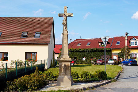
Stone cross
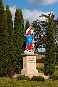
Statue of the Madonna of Svatý Hostýn


Individual evidence
- ↑ Český statistický úřad - The population of the Czech municipalities as of January 1, 2019 (PDF; 7.4 MiB)