
Igé (Saône-et-Loire)
| Igé | ||
|---|---|---|
|
||
| region | Bourgogne-Franche-Comté | |
| Department | Saône-et-Loire | |
| Arrondissement | Mâcon | |
| Canton | Hurigny | |
| Community association | Mâconnais Beaujolais Agglomération | |
| Coordinates | 46 ° 24 ' N , 4 ° 44' E | |
| height | 225-600 m | |
| surface | 14.61 km 2 | |
| Residents | 871 (January 1, 2017) | |
| Population density | 60 inhabitants / km 2 | |
| Post Code | 71960 | |
| INSEE code | 71236 | |
| Website | http://www.mairie-ige.fr/ | |
 View of Igé |
||

Cluny is a French municipality with 871 inhabitants (as of January 1 2017) in the department of Saone-et-Loire in the region of Bourgogne Franche-Comté . It belongs to the arrondissement of Mâcon and the canton of Hurigny (until 2015: canton of Mâcon-Nord ).
geography
Igé is located in the Mâconnais in the Bourgogne wine region . Igé is surrounded by the neighboring communities Azé in the north, Saint-Maurice-de-Satonnay in the east and northeast, Verzé in the south and southwest and Cluny in the west and northwest.
Population development
| year | 1962 | 1968 | 1975 | 1982 | 1990 | 1999 | 2006 | 2012 |
|---|---|---|---|---|---|---|---|---|
| Residents | 741 | 703 | 646 | 669 | 729 | 768 | 854 | 853 |
| Source: Cassini and INSEE | ||||||||
Attractions
- Saint-Germain church , neoclassical church building from the 19th century
- Chapel of Sainte-Bénédicte in Domange from the 10th century
- Castle Igé ( Château d'Igé ) from the 12th century, now a hotel
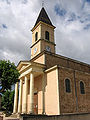
Saint Germain Church

Chapel of Sainte-Bénédicte

Igé Castle


_-_1.JPG)
Web links
Commons : Igé - collection of images, videos and audio files