
Chaintré
| Chaintré | ||
|---|---|---|
.svg)
|
|
|
| region | Bourgogne-Franche-Comté | |
| Department | Saône-et-Loire | |
| Arrondissement | Mâcon | |
| Canton | La Chapelle-de-Guinchay | |
| Community association | Mâconnais Beaujolais Agglomération | |
| Coordinates | 46 ° 16 ′ N , 4 ° 46 ′ E | |
| height | 171-285 m | |
| surface | 3.31 km 2 | |
| Residents | 584 (January 1, 2017) | |
| Population density | 176 inhabitants / km 2 | |
| Post Code | 71570 | |
| INSEE code | 71074 | |
| Website | http://www.chaintre.fr/ | |
 Town hall (Mairie) of Chaintré |
||

Chaintré is a French municipality with 584 inhabitants (at January 1, 2017) in the department of Saone-et-Loire in the region of Bourgogne Franche-Comté . The municipality is part of the arrondissement of Mâcon and part of the canton of La Chapelle-de-Guinchay . The inhabitants are called Chaintréens .
geography
Chaintré is located in the Mâconnais countryside in the immediate vicinity of Beaujolais in the Bourgogne wine-growing region ; Here, the Crémant de Bourgogne is mainly produced from the grapes . The white wine Pouilly-Fuissé can also be produced.
Chaintré is surrounded by the neighboring communities of Vinzelles in the north, Varennes-lès-Mâcon in the east and northeast, Crêches-sur-Saône in the south and southeast, Chânes in the south, Leynes in the west and Fuissé in the north-west.
Population development
| year | 1962 | 1968 | 1975 | 1982 | 1990 | 1999 | 2006 | 2011 | 2016 |
|---|---|---|---|---|---|---|---|---|---|
| Residents | 396 | 398 | 352 | 372 | 503 | 503 | 519 | 525 | 572 |
| Source: Cassini and INSEE | |||||||||
Attractions
- Notre-Dame-de-l'Assomption church
- Chaintré Castle

Notre-Dame-de-l'Assomption church
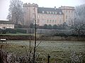
Chaintré Castle

_-_1.JPG)