
Bourgvilain
| Bourgvilain | ||
|---|---|---|
|
||
| region | Bourgogne-Franche-Comté | |
| Department | Saône-et-Loire | |
| Arrondissement | Mâcon | |
| Canton | La Chapelle-de-Guinchay | |
| Community association | Saint-Cyr Mère Boitier between Charolais and Mâconnais | |
| Coordinates | 46 ° 22 ′ N , 4 ° 38 ′ E | |
| height | 260-681 m | |
| surface | 11.81 km 2 | |
| Residents | 331 (January 1, 2017) | |
| Population density | 28 inhabitants / km 2 | |
| Post Code | 71520 | |
| INSEE code | 71050 | |
| Website | http://www.bourgvilain.fr/ | |
 Town hall (Mairie) of Bourgvilain |
||

Bourgvilain is a French municipality with 331 inhabitants (as of January 1 2017) in the department of Saone-et-Loire in the region of Bourgogne Franche-Comté (before 2016 Bourgogne ). It belongs to the Arrondissement of Mâcon and the canton of La Chapelle-de-Guinchay (until 2015: Canton Tramayes ).
geography
Bourgvilain is located about 18 kilometers west-northwest of Mâcon . Neighboring municipalities of Bourgvilain are Sainte-Cécile in the north and west, Sologny in the east and northeast, Pierreclos in the southeast, Saint-Point in the south and Navour-sur-Grosne in the west and southwest.
Population development
| year | 1962 | 1968 | 1975 | 1982 | 1990 | 1999 | 2006 | 2011 | 2016 |
| Residents | 192 | 210 | 275 | 278 | 276 | 321 | 333 | 328 | 326 |
| Source: Cassini and INSEE | |||||||||
Attractions
- Saint-Denis church
- Corcelle Castle from the 15th century, a historic monument since 1976
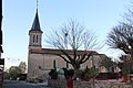
Saint-Denis church

Corcelle Castle

_-_1.JPG)
Web links
Commons : Bourgvilain - collection of images, videos and audio files