
Jalogny
| Jalogny | ||
|---|---|---|
|
||
| region | Bourgogne-Franche-Comté | |
| Department | Saône-et-Loire | |
| Arrondissement | Mâcon | |
| Canton | Cluny | |
| Community association | Clunisois | |
| Coordinates | 46 ° 25 ' N , 4 ° 38' E | |
| height | 242-480 m | |
| surface | 10.15 km 2 | |
| Residents | 359 (January 1, 2017) | |
| Population density | 35 inhabitants / km 2 | |
| Post Code | 71250 | |
| INSEE code | 71240 | |
 Jalogny Town Hall (Mairie) |
||

Jalogny is a French municipality with 359 inhabitants (as of January 1 2017) in the department of Saone-et-Loire in the region of Bourgogne Franche-Comté (before 2016 Bourgogne ). The municipality belongs to the arrondissement of Mâcon and the canton of Cluny .
geography
Jalogny is located about 23 kilometers northwest of Mâcon and about 37 kilometers south-southwest of Chalon-sur-Saône . Neighboring communities of Jalogny are Cluny in the north and east, Sainte-Cécile in the south, Mazille in the south and south-west and Château in the west and north-west.
Population development
| year | 1962 | 1968 | 1975 | 1982 | 1990 | 1999 | 2006 | 2011 | 2016 |
| Residents | 243 | 221 | 246 | 257 | 270 | 260 | 308 | 344 | 354 |
| Source: Cassini and INSEE | |||||||||
Attractions
- Saint-Valentin church, built around 1100, monument historique since 1929
- Saint-Jean-d'Évangéliste church from the 11th / 12th centuries Century in Vaux
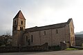
Saint-Vanlentin Church

Saint-Jean-d'Évangéliste church


Web links
Commons : Jalogny - collection of images, videos and audio files