
Varennes-lès-Mâcon
| Varennes-lès-Mâcon | ||
|---|---|---|
|
||
| region | Bourgogne-Franche-Comté | |
| Department | Saône-et-Loire | |
| Arrondissement | Mâcon | |
| Canton | Mâcon-2 | |
| Community association | Mâconnais Beaujolais Agglomération | |
| Coordinates | 46 ° 16 ' N , 4 ° 48' E | |
| height | 167-184 m | |
| surface | 4.75 km 2 | |
| Residents | 548 (January 1, 2017) | |
| Population density | 115 inhabitants / km 2 | |
| Post Code | 71000 | |
| INSEE code | 71556 | |
| Website | http://www.varenneslesmacon.fr/ | |
 Town hall (Mairie) of Varennes-lès-Mâcon |
||

Varennes-lès-Mâcon is a French commune in the department of Saone-et-Loire in the region of Bourgogne Franche-Comté (before 2016 Bourgogne ). It belongs to the arrondissement of Mâcon and the canton of Mâcon-2 (until 2015 Mâcon-Sud ). The community has 548 inhabitants (as of January 1, 2017).
geography
Varennes-lès-Mâcon is located about six kilometers south-southwest of the city center of Mâcon on the Saône . Varennes-lès-Mâcon is surrounded by the neighboring communities of Mâcon in the north, Grièges in the east, Cormoranche-sur-Saône in the south-east, Crêches-sur-Saône in the south, Chaintré in the south-west and Vinzelles in the west.
The A406 autoroute runs through the municipality .
Population development
| year | 1962 | 1968 | 1975 | 1982 | 1990 | 1999 | 2006 | 2011 | 2016 |
| Residents | 378 | 437 | 429 | 455 | 438 | 480 | 518 | 555 | 539 |
| Source: Cassini and INSEE | |||||||||
Attractions
- Saint-Marcel church from the 11th century
- Varennes Castle from the 16th century
- Beaulieu Castle, Monument historique since 1992

Saint-Marcel church
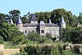
Varennes Castle
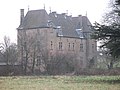
Beaulieu Castle


_-_1.JPG)
Personalities
- Fernand Dubief (1850-1916), politician
Web links
Commons : Varennes-lès-Mâcon - Collection of images, videos and audio files