
Saint-Maurice-de-Satonnay
| Saint-Maurice-de-Satonnay | ||
|---|---|---|

|
|
|
| region | Bourgogne-Franche-Comté | |
| Department | Saône-et-Loire | |
| Arrondissement | Mâcon | |
| Canton | Hurigny | |
| Community association | Mâconnais Beaujolais Agglomération | |
| Coordinates | 46 ° 25 ' N , 4 ° 47' E | |
| height | 201–343 m | |
| surface | 10.33 km 2 | |
| Residents | 486 (January 1, 2017) | |
| Population density | 47 inhabitants / km 2 | |
| Post Code | 71260 | |
| INSEE code | 71460 | |
| Website | http://www.saint-maurice-de-satonnay.fr/ | |
 Town hall (Mairie) of Saint-Maurice-de-Satonnay |
||

Saint-Maurice-de-Satonnay is a French commune in the department of Saone-et-Loire in the region of Bourgogne Franche-Comté (before 2016 Bourgogne ). It belongs to the arrondissement of Mâcon and the canton of Hurigny (until 2015 Lugny ). The community has 486 inhabitants (as of January 1, 2017).
geography
Saint-Maurice-de-Satonnay is about 13 kilometers north-northwest of the city center of Mâcon . Saint-Maurice-de-Satonnay is surrounded by the neighboring communities of Péronne in the north, Clessé in the east and north-east, Laizé in the east and south-east, Verzé in the south and south-west, Igé in the west and south-west and Azé in the west and north-west.
The municipality belongs to the Bourgogne wine region .
Population development
| year | 1962 | 1968 | 1975 | 1982 | 1990 | 1999 | 2006 | 2011 | 2016 |
| Residents | 296 | 269 | 275 | 313 | 349 | 346 | 415 | 421 | 495 |
| Source: Cassini and INSEE | |||||||||
Attractions
- Saint-Denis church
- Saint-Mauris Castle

Saint-Denis church
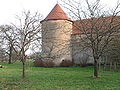
Saint-Mauris Castle

_-1.JPG)