
Péronne (Saône-et-Loire)
| Péronne | ||
|---|---|---|
|
||
| region | Bourgogne-Franche-Comté | |
| Department | Saône-et-Loire | |
| Arrondissement | Mâcon | |
| Canton | Hurigny | |
| Community association | Mâconnais Beaujolais Agglomération | |
| Coordinates | 46 ° 27 ' N , 4 ° 51' E | |
| height | 177-441 m | |
| surface | 10.56 km 2 | |
| Residents | 652 (January 1, 2017) | |
| Population density | 62 inhabitants / km 2 | |
| Post Code | 71260 | |
| INSEE code | 71345 | |
| Website | http://www.peronne-bourgogne.com/ | |
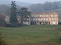
_(Plan_Large).jpg) View of Péronne |
||

Péronne is a French municipality with 652 inhabitants (as of January 1 2017) in the department of Saone-et-Loire in the region of Bourgogne Franche-Comté . It belongs to the arrondissement of Mâcon and the canton of Hurigny (until 2015: canton of Lugny ). The inhabitants are called Péronnais .
geography
Péronne is located about 14 kilometers north-northwest of the city center of Mâcon in the Mâconnais in the Bourgogne wine region . Péronne is surrounded by the neighboring communities of Lugny in the north, Burgy in the northeast, Viré in the east, Clessé in the south and southeast, Saint-Maurice-de-Satonnay in the south, Azé in the west and southwest and Saint-Gengoux-de-Scissé in the west and Northwest.
Population development
| year | 1962 | 1968 | 1975 | 1982 | 1990 | 1999 | 2006 | 2016 |
|---|---|---|---|---|---|---|---|---|
| Residents | 324 | 377 | 349 | 361 | 407 | 454 | 497 | 653 |
| Source: Cassini and INSEE | ||||||||
Attractions
- Church of Sainte-Madeleine from the 11th / 12th centuries Century, since 1927/1946 Monument historique
- La Tour-Penet castle from the 17th century
- Vaux-sous-Targe castle from the 15th century, monument historique since 2000

Sainte-Madeleine church

La Tour-Penet Castle
Vaux-sous-Targe castle

_-_1.JPG)
_-_2.JPG)