
Verosvres
| Verosvres | ||
|---|---|---|
|
||
| region | Bourgogne-Franche-Comté | |
| Department | Saône-et-Loire | |
| Arrondissement | Mâcon | |
| Canton | La Chapelle-de-Guinchay | |
| Community association | Saint-Cyr Mère Boitier between Charolais and Mâconnais | |
| Coordinates | 46 ° 24 ' N , 4 ° 27' E | |
| height | 326-596 m | |
| surface | 22.96 km 2 | |
| Residents | 448 (January 1, 2017) | |
| Population density | 20 inhabitants / km 2 | |
| Post Code | 71220 | |
| INSEE code | 71571 | |

Verosvres is a French municipality with 448 inhabitants (as of January 1 2017) in the department of Saone-et-Loire in the region of Bourgogne Franche-Comté (before 2016 Bourgogne ). It belongs to the arrondissement of Mâcon and the canton of La Chapelle-de-Guinchay (until 2015: canton of Saint-Bonnet-de-Joux ). The inhabitants are called Vroulons .
geography
Verosvres is located about 50 kilometers southwest of Chalon-sur-Saône . Neighboring municipalities of Verosvres are Suin in the north, Sivignon in the northeast, Trivy in the east, Dompierre-les-Ormes in the southeast, Montmelard in the south and Beaubery in the west.
Route nationale 79 runs through the municipality .
Population development
| year | 1962 | 1968 | 1975 | 1982 | 1990 | 1999 | 2006 | 2011 | 2016 |
| Residents | 606 | 555 | 486 | 475 | 425 | 402 | 482 | 433 | 448 |
| Source: Cassini and INSEE | |||||||||
Attractions
- Saint Laurent Church
- Le Terreau Castle, monument historique since 1984
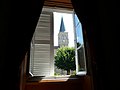
Bell tower of the Saint-Laurent church

Verosvres Castle


Personalities
- Margareta Maria Alacoque (1647–1690), nun and mystic
Web links
Commons : Verosvres - collection of images, videos and audio files