
Lournand
| Lournand | ||
|---|---|---|
|
||
| region | Bourgogne-Franche-Comté | |
| Department | Saône-et-Loire | |
| Arrondissement | Mâcon | |
| Canton | Cluny | |
| Community association | Clunisois | |
| Coordinates | 46 ° 27 ' N , 4 ° 39' E | |
| height | 222-506 m | |
| surface | 11.22 km 2 | |
| Residents | 331 (January 1, 2017) | |
| Population density | 30 inhabitants / km 2 | |
| Post Code | 71250 | |
| INSEE code | 71264 | |

Lournand is a French municipality with 331 inhabitants (as of January 1 2017) in the department of Saone-et-Loire in the region of Bourgogne Franche-Comté (before 2016 Burgundy ). The municipality belongs to the arrondissement of Mâcon and the canton of Cluny .
geography
Lournand is located about 20 kilometers northwest of Mâcon and about 35 kilometers south-southwest of Chalon-sur-Saône . Neighboring municipalities of Lournand are Flagy in the north and northwest, Massilly in the northeast, Cortambert in the east, Cluny in the south and La Vineuse sur Fregande in the west.
Population development
| year | 1962 | 1968 | 1975 | 1982 | 1990 | 1999 | 2006 | 2011 | 2016 |
| Residents | 336 | 335 | 318 | 320 | 301 | 319 | 347 | 328 | 332 |
| Source: Cassini and INSEE | |||||||||
Attractions
- Sainte-Marie Church (Notre-Dame-de-l'Assomption)
- Lourdon castle ruins from the 9th century

Sainte-Marie Church (Notre-Dame-de-l'Assomption)
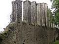
Lourdon castle ruins

.jpg)
Web links
Commons : Lournand - collection of images, videos and audio files