
Davayé
| Davayé | ||
|---|---|---|

|
|
|
| region | Bourgogne-Franche-Comté | |
| Department | Saône-et-Loire | |
| Arrondissement | Mâcon | |
| Canton | La Chapelle-de-Guinchay (main town) | |
| Community association | Mâconnais Beaujolais Agglomération | |
| Coordinates | 46 ° 18 ' N , 4 ° 45' E | |
| height | 185-325 m | |
| surface | 4.17 km 2 | |
| Residents | 694 (January 1, 2017) | |
| Population density | 166 inhabitants / km 2 | |
| Post Code | 71960 | |
| INSEE code | 71169 | |
| Website | http://davaye.pagesperso-orange.fr/ | |
 Town hall (Mairie) of Davayé |
||

Davayé is a French municipality with 694 inhabitants (as of January 1 2017) in the department of Saone-et-Loire in the region of Bourgogne Franche-Comté . The municipality is part of the arrondissement of Mâcon and the canton of La Chapelle-de-Guinchay . The inhabitants are called Davayoutis .
geography
Davayé is in the Beaujolais countryside , in the Bourgogne wine-growing region ; Here, the Crémant de Bourgogne is mainly produced from the grapes .
Davayé is surrounded by the neighboring communities of Prissé in the north, Charnay-lès-Mâcon in the east, Solutré-Pouilly in the south and west and Vergisson in the west and north-west.
Route nationale 79 runs through the municipality .
Population development
| year | 1962 | 1968 | 1975 | 1982 | 1990 | 1999 | 2006 | 2011 | 2016 |
|---|---|---|---|---|---|---|---|---|---|
| Residents | 427 | 466 | 527 | 610 | 630 | 617 | 682 | 678 | 682 |
| Source: Cassini and INSEE | |||||||||
Attractions
- Saint-Julien church
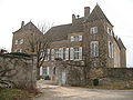
- Chevignes Castle from the 17th century
- Rossan Castle, originally from the 15th century

Saint-Julien church

Entrance to the Chevignes Castle
Rossan Castle

_-_1.JPG)
_-_1.JPG)