
Roure (Alpes-Maritimes)
| Roure | ||
|---|---|---|
.svg)
|
|
|
| region | Provence-Alpes-Cote d'Azur | |
| Department | Alpes-Maritimes | |
| Arrondissement | Nice | |
| Canton | Tourrette-Levens | |
| Community association | Nice Cote d'Azur | |
| Coordinates | 44 ° 5 ' N , 7 ° 5' E | |
| height | 500-2,339 m | |
| surface | 40.3 km 2 | |
| Residents | 173 (January 1, 2017) | |
| Population density | 4 inhabitants / km 2 | |
| Post Code | 06420 | |
| INSEE code | 06111 | |
 Saint-Sébastien church |
||

Roure is a French commune in the Alpes-Maritimes in the region Provence-Alpes-Cote d'Azur . It belongs to the Arrondissement of Nice , the Canton of Tourrette-Levens and the Métropole Nice Côte d'Azur . The residents call themselves rourois .
geography
Roure is located in the French Maritime Alps . It borders Isola to the north, Saint-Sauveur-sur-Tinée to the east, Ilonse to the south and Roubion to the west .
Population development
| year | 1962 | 1968 | 1975 | 1982 | 1990 | 1999 | 2008 | 2012 |
|---|---|---|---|---|---|---|---|---|
| Residents | 91 | 98 | 71 | 112 | 147 | 167 | 210 | 205 |
Attractions
See: List of Monuments historiques in Roure (Alpes-Maritimes)
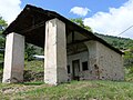
Saint-Sébastien Chapel

Saint Laurent Church


literature
- Le Patrimoine des Communes des Alpes-Maritimes . Flohic Editions, Volume 2, Paris 2000, ISBN 2-84234-071-X , pp. 863-865.
Web links
Commons : Roure - collection of images, videos and audio files