Chapelle spinasses
| Chapelle spinasses | ||
|---|---|---|

|
|
|
| region | Nouvelle-Aquitaine | |
| Department | Corrèze | |
| Arrondissement | Ussel | |
| Canton | Égletons | |
| Community association | Ventadour-Égletons-Monédières | |
| Coordinates | 45 ° 22 ' N , 2 ° 3' E | |
| height | 564-645 m | |
| surface | 5.89 km 2 | |
| Residents | 115 (January 1, 2017) | |
| Population density | 20 inhabitants / km 2 | |
| Post Code | 19300 | |
| INSEE code | 19046 | |
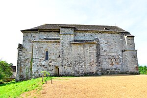
 Notre-Dame-de-la-Nativité church |
||
Chapelle-Spinasse is a French municipality with 115 inhabitants (at January 1, 2017) in the Correze in the region Nouvelle-Aquitaine . The inhabitants call themselves chapellois (es).
geography
The municipality is located in the Massif Central on the left bank of the upper reaches of the Doustre and is surrounded by extensive fields and forests. Tulle , the prefecture of the department, is about 25 kilometers southwest and Égletons about 7 kilometers north and Ussel about 35 kilometers northeast.
Neighboring communities of Chapelle-Spinasse are Rosiers-d'Égletons in the north, Moustier-Ventadour in the east, Saint-Hilaire-Foissac in the southeast and Montaignac-Saint-Hippolyte in the south and west.
coat of arms
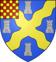
Blazon : In blue a continuous golden wave andreas cross angled by four silver towers and in the right upper corner red-gold box .
Population development
| year | 1962 | 1968 | 1975 | 1982 | 1990 | 1999 | 2007 | 2016 |
| Residents | 117 | 124 | 134 | 119 | 137 | 133 | 113 | 116 |
Attractions
- Notre-Dame-de-la-Nativité (Nativity of the Virgin) Church
- Étang de Gros, a 12 hectare pond created in the 18th century
