Latronche
|
Latronche La Tronça |
||
|---|---|---|

|
|
|
| region | Nouvelle-Aquitaine | |
| Department | Corrèze | |
| Arrondissement | Ussel | |
| Canton | Haute-Dordogne | |
| Community association | Haute-Corrèze Communauté | |
| Coordinates | 45 ° 18 ' N , 2 ° 14' E | |
| height | 321-606 m | |
| surface | 19.79 km 2 | |
| Residents | 134 (January 1, 2017) | |
| Population density | 7 inhabitants / km 2 | |
| Post Code | 19160 | |
| INSEE code | 19110 | |
 St-Pierre Church |
||
Latronche ( La tronca in Occitan ) is a French municipality with 134 inhabitants (at January 1, 2017) in the Correze in the region Nouvelle-Aquitaine .
geography
The municipality is located in the Massif Central , around three kilometers west of the Dordogne and is surrounded by extensive forests.
Tulle , the prefecture of the department is about 50 kilometers to the west and Égletons about 25 kilometers to the northwest and Ussel about 30 kilometers to the northeast.
Neighboring municipalities of Latronche are Neuvic in the north and east, Chalvignac in the southeast, Soursac in the south, Saint-Pantaléon-de-Lapleau in the west and Saint-Hilaire-Luc in the north-west.
coat of arms
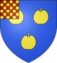
Description : In blue three golden apples , right up in red and gold geschachte crossing (references to. House Ventadour ).
Population development
| year | 1962 | 1968 | 1975 | 1982 | 1990 | 1999 | 2007 | 2016 |
| Residents | 157 | 187 | 167 | 140 | 123 | 154 | 134 | 135 |
