Thalamy
|
Thalamy Talamin |
||
|---|---|---|

|
|
|
| region | Nouvelle-Aquitaine | |
| Department | Corrèze | |
| Arrondissement | Ussel | |
| Canton | Haute-Dordogne | |
| Community association | Haute-Corrèze Communauté | |
| Coordinates | 45 ° 31 ' N , 2 ° 28' E | |
| height | 632-768 m | |
| surface | 11.84 km 2 | |
| Residents | 97 (January 1, 2017) | |
| Population density | 8 inhabitants / km 2 | |
| Post Code | 19200 | |
| INSEE code | 19266 | |
Thalamy ( Talamin in Occitan ) is a French municipality with 97 inhabitants (at January 1, 2017) in the Correze in the region Nouvelle-Aquitaine .
geography
The municipality is located in the Massif Central , in the valley of the Dognon River , west of the Bort-les-Orgues dam and therefore not far from the border with the Cantal department .
Tulle , the prefecture of the department, is about 80 kilometers southwest, Ussel about 15 kilometers northwest and Bort-les-Orgues about 15 kilometers south.
Neighboring municipalities of Thalamy are Saint-Étienne-aux-Clos in the north, Confolent-Port-Dieu in the northeast, Monestier-Port-Dieu in the east, Sarroux-Saint Julien with Saint-Julien-près-Bort in the south and Saint-Bonnet-près -Bort in the west.
traffic
The place is about 13 kilometers south of exit 24 of the A89 autoroute .
coat of arms
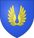
Description : In blue a golden open flight .
Population development
| year | 1962 | 1968 | 1975 | 1982 | 1990 | 1999 | 2007 | 2016 |
| Residents | 120 | 128 | 117 | 98 | 92 | 85 | 85 | 96 |
economy
The Ussel-Thalamy airfield , operated by the Chambre de commerce et d'industrie de Tulle et Ussel (Tulle and Ussel Chamber of Commerce and Industry), is located halfway to Ussel in the municipal areas of Saint-Exupéry-les-Roches and Saint -Bonnet-près-Bort.
Web links
- Thalamy on annuaire-mairie.fr
