Palisse
|
Palisse palica |
||
|---|---|---|

|
|
|
| region | Nouvelle-Aquitaine | |
| Department | Corrèze | |
| Arrondissement | Ussel | |
| Canton | Haute-Dordogne | |
| Community association | Haute-Corrèze Communauté | |
| Coordinates | 45 ° 25 ′ N , 2 ° 12 ′ E | |
| height | 511-706 m | |
| surface | 32.89 km 2 | |
| Residents | 225 (January 1, 2017) | |
| Population density | 7 inhabitants / km 2 | |
| Post Code | 19160 | |
| INSEE code | 19157 | |
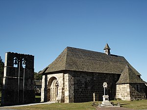
 The church of Palisse |
||
Palisse ( palica in Occitan ) is a French municipality with 225 inhabitants (at January 1, 2017) in the Correze in the region Nouvelle-Aquitaine .
geography
The village is located in the Massif Central south of the Plateau de Millevaches and the Regional Nature Park Millevaches en Limousin not far from the Triouzoune, a right tributary of the Dordogne .
Tulle , the prefecture of the department, is about 55 kilometers southwest, Ussel about 20 kilometers northeast and Égletons about 17 kilometers slightly southwest.
Neighboring municipalities of Palisse are Saint-Angel in the north, Valiergues in the northeast, Chirac-Bellevue in the east, Neuvic in the southeast, Lamazière-Basse in the south, Darnets in the west and Combressol in the northwest.
traffic
The place is about 15 kilometers slightly southwest of exit 23 of the A89 autoroute .
coat of arms
Description : The coat of arms is quartered , fields 1 and 4 are quartered in gold and red, the others show three red lions each in gold .
Population development
| year | 1962 | 1968 | 1975 | 1982 | 1990 | 1999 | 2007 | 2016 |
| Residents | 83 | 106 | 109 | 120 | 124 | 121 | 227 |
Attractions
- The Saint-Martial church , a religious building from the 12th, 13th and 14th centuries, has been classified as a Monument historique since September 15, 1993 .
- The dam Barrage de Neuvic d'Ussel , located about 12 kilometers southeast.
Individual evidence
- ↑ http://s3.e-monsite.com/2011/03/13/99431175communespnr-pdf.pdf
- ↑ Entry no. PA00099825 in the Base Mérimée of the French Ministry of Culture (French)
- ↑ Barrage de Neuvic d'Ussel. In: Structurae
- ↑ Le lac de la Triouzoune à Neuvic
Web links
- Palisse on annuaire-mairie.fr
