Alleyrat (Corrèze)
|
Alleyrat Alairac |
||
|---|---|---|

|
|
|
| region | Nouvelle-Aquitaine | |
| Department | Corrèze | |
| Arrondissement | Ussel | |
| Canton | Plateau de Millevaches | |
| Community association | Haute-Corrèze Communauté | |
| Coordinates | 45 ° 35 ' N , 2 ° 13' E | |
| height | 654-844 m | |
| surface | 14.76 km 2 | |
| Residents | 98 (January 1, 2017) | |
| Population density | 7 inhabitants / km 2 | |
| Post Code | 19200 | |
| INSEE code | 19006 | |
Alleyrat ( Alairac in Occitan ) is a French municipality with 98 inhabitants (at January 1, 2017) in the Correze in the region Nouvelle-Aquitaine . The inhabitants call themselves Alleyratois (es) .
geography
The municipality is located in the Massif Central on the Plateau de Millevaches and therefore also in the Millevaches en Limousin Regional Nature Park .
Tulle , the prefecture of the département, is located about 65 kilometers southwest, Égletons about 30 kilometers southwest and Ussel about 10 kilometers southeast.
Neighboring communities of Alleyrat are Saint-Germain-Lavolps in the north, Chaveroche in the east, Saint-Angel in the south and Meymac in the west.
traffic
The place is about ten kilometers northwest of exit 23 of the A89 autoroute .
coat of arms
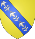
Blazon : a blue sloping bar with three silver lilies in gold .
Population development
| year | 1962 | 1968 | 1975 | 1982 | 1990 | 1999 | 2007 | 2016 |
| Residents | 103 | 130 | 102 | 83 | 96 | 99 | 103 | 95 |
Attractions
- Saint Pierre Church , a sacred building from the 14th century

