Laval-sur-Luzège
|
Laval-sur-Luzège La Val |
||
|---|---|---|

|
|
|
| region | Nouvelle-Aquitaine | |
| Department | Corrèze | |
| Arrondissement | Ussel | |
| Canton | Égletons | |
| Community association | Ventadour-Égletons-Monédières | |
| Coordinates | 45 ° 16 ' N , 2 ° 8' E | |
| height | 260-560 m | |
| surface | 16.94 km 2 | |
| Residents | 99 (January 1, 2017) | |
| Population density | 6 inhabitants / km 2 | |
| Post Code | 19550 | |
| INSEE code | 19111 | |
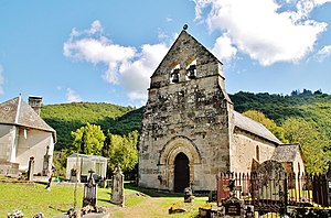
 Saint Martin Church |
||
Laval-sur-Luzège ( La Val in Occitan ) is a French municipality with 99 inhabitants (at January 1, 2017) in the Correze in the region Nouvelle-Aquitaine .
geography
The community is located in the Massif Central , on the Luzège River , about five kilometers north of its confluence with the Dordogne and is surrounded by extensive forests. Tulle , the prefecture of the department is around 35 kilometers to the west and Égletons around 20 kilometers to the north.
Neighboring municipalities of Laval-sur-Luzège are Saint-Hilaire-Foissac in the north, Lapleau in the northeast, Soursac in the east, Auriac south and Saint-Merd-de-Lapleau in the west.
Population development
| year | 1962 | 1968 | 1975 | 1982 | 1990 | 1999 | 2007 | 2016 |
| Residents | 161 | 190 | 161 | 126 | 96 | 89 | 91 | 99 |
Web links
Commons : Laval-sur-Luzège - Collection of images, videos and audio files
