Dolignon
| Dolignon | ||
|---|---|---|
|
|
||
| region | Hauts-de-France | |
| Department | Aisne | |
| Arrondissement | Vervins | |
| Canton | Vervins | |
| Community association | Portes de la Thiérache | |
| Coordinates | 49 ° 44 ' N , 4 ° 5' E | |
| height | 126-213 m | |
| surface | 3.38 km 2 | |
| Residents | 49 (January 1, 2017) | |
| Population density | 14 inhabitants / km 2 | |
| Post Code | 02360 | |
| INSEE code | 02266 | |
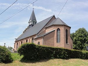
 Saint Michel church in Dolignon |
||
Dolignon is a French municipality with 49 inhabitants (at January 1, 2017) in the department of Aisne in the region of Hauts-de-France .
During the First World War , German soldiers were quartered in the church in the village of Saint-Michel .
geography
Départementsstraße 110 runs through the village in the Laon arrondissement in the canton of Rozoy-sur-Serre . North-east of the village is the Bois de Dolignon forest .
Population development
| year | 1962 | 1968 | 1975 | 1982 | 1990 | 1999 | 2007 | 2016 |
| Residents | 88 | 84 | 80 | 78 | 55 | 45 | 58 | 50 |
| Sources: Cassini and INSEE | ||||||||
In 1793 the place had 145 inhabitants. In 1821 the population reached the largest number with 217 people, but has fallen continuously since then. In 1911 only 97, 1962 88 and 1999 45 people lived in the village. Since then the number has increased again a little. In 2009 there were 61 residents.
Web links
Commons : Dolignon - collection of images, videos and audio files
Individual evidence
- ↑ Johannes Trimborn, War Diary of Dr. Johannes Trimborn , number 6, Magdeburg City Archives
