
Luzoir
| Luzoir | ||
|---|---|---|
|
||
| region | Hauts-de-France | |
| Department | Aisne | |
| Arrondissement | Vervins | |
| Canton | Vervins | |
| Community association | Thiérache du Center | |
| Coordinates | 49 ° 56 ' N , 3 ° 58' E | |
| height | 128-221 m | |
| surface | 10.99 km 2 | |
| Residents | 285 (January 1, 2017) | |
| Population density | 26 inhabitants / km 2 | |
| Post Code | 02500 | |
| INSEE code | 02445 | |

Luzoir is a French municipality with 285 inhabitants (at January 1, 2017) in the department of Aisne in the region of Hauts-de-France (before 2016 Picardy ). It belongs to the arrondissement of Vervins , the canton of Vervins (until 2015 La Capelle ) and the municipal association Thiérache du Center .
geography
Luzoir is surrounded by the neighboring communities of Étréaupont in the south, Gergny in the west, Sommeron in the northwest, Clairfontaine in the north and the municipalities of Wimy in the canton of Hirson in the northeast and Effry in the southeast.
Population development
| 1962 | 1968 | 1975 | 1982 | 1990 | 1999 | 2006 | 2015 | |
|---|---|---|---|---|---|---|---|---|
| 373 | 381 | 348 | 328 | 301 | 279 | 286 | 289 | |
| Source: Cassini and INSEE | ||||||||
Attractions
- Saint-Sylvestre church
- The “Green Axis of Thiérache ”, a hiking trail on the old Guise - Hirson railway , runs through Luzoir.
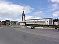
Saint-Sylvestre church

Old Luzoir train station
_place_de_l%27%C3%A9glise.JPG)
_ancienne_gare,_Axe_Vert_de_la_Thi%C3%A9arache.JPG)
Web links
Commons : Luzoir - collection of images, videos and audio files