Grougis
| Grougis | ||
|---|---|---|
|
|
||
| region | Hauts-de-France | |
| Department | Aisne | |
| Arrondissement | Vervins | |
| Canton | Guise | |
| Community association | Thiérache Sambre et Oise | |
| Coordinates | 49 ° 57 ' N , 3 ° 32' E | |
| height | 120-178 m | |
| surface | 11.26 km 2 | |
| Residents | 358 (January 1, 2017) | |
| Population density | 32 inhabitants / km 2 | |
| Post Code | 02110 | |
| INSEE code | 02358 | |
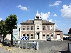
 Town hall (Mairie) of Grougis |
||
Grougis is a French municipality with 358 inhabitants (at January 1, 2017) in the department of Aisne in the region of Hauts-de-France (before 2016 Picardy ). It belongs to the arrondissement of Vervins , the canton of Guise (until 2015 Wassigny ) and the municipal association Thiérache Sambre et Oise .
history
From 1900 to 1951 Grougis was on the railway line from Guise to Le Catelet , on which mainly mail, merchandise, sugar beets and above all the residents and workers from the area were transported. After 1945 the traffic decreased due to the increasing transport by trucks and buses, so that the line was closed on January 1st, 1951.
Route between Bohain-en-Vermandois and Lesquielles-Saint-Germain .
geography
Grougis is surrounded by the neighboring communities of Mennevret in the north, Petit-Verly in the northeast, Vadencourt in the southeast, Aisonville-et-Bernoville in the southwest and the municipality of Seboncourt in the canton of Bohain-en-Vermandois in the west.
Population development
| year | 1962 | 1968 | 1975 | 1982 | 1990 | 1999 | 2005 | 2015 |
| Residents | 439 | 420 | 361 | 340 | 320 | 350 | 368 | 366 |
| Source: Cassini and INSEE | ||||||||
Attractions
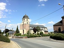
- Saint Martin Church


