
Vadencourt (Aisne)
| Vadencourt | ||
|---|---|---|
|
||
| region | Hauts-de-France | |
| Department | Aisne | |
| Arrondissement | Vervins | |
| Canton | Guise | |
| Community association | Thiérache Sambre et Oise | |
| Coordinates | 49 ° 56 ' N , 3 ° 35' E | |
| height | 82-152 m | |
| surface | 12.24 km 2 | |
| Residents | 540 (January 1, 2017) | |
| Population density | 44 inhabitants / km 2 | |
| Post Code | 02120 | |
| INSEE code | 02757 | |
 Town Hall (Mairie) of Vadencourt |
||

Vadencourt is a French municipality with 540 inhabitants (as of January 1 2017) in the department of Aisne in the region of Hauts-de-France . It belongs to the Arrondissement of Vervins , the Canton of Guise and the municipal association Thiérache Sambre et Oise .
history
The municipality of Vadencourt was founded in 1793. In 1811 the village of Bohéries was incorporated and in 1970 the municipality was renamed Vadencourt-et-Bohéries . Since the incorporation of Longchamps on January 1, 1971, the municipality has had its current name.
geography
Vadencourt is surrounded by the neighboring communities of Petit-Verly in the north-west, Grand-Verly in the north, Lesquielles-Saint-Germain in the north-east, the canton capital Guise in the south-east, Proix in the south, Noyales in the south-east, Aisonville-et-Bernoville in the south-west and Grougis in the West.
Population development
| year | 1962 | 1968 | 1975 | 1982 | 1990 | 1999 | 2007 | 2015 |
| Residents | 552 | 548 | 709 | 664 | 631 | 605 | 630 | 561 |
| Source: Cassini and INSEE | ||||||||
Attractions
- Saint-Quentin church in Vadencourt
- Sainte-Geneviève church in Longchamps
- Former Cistercian Abbey of Bohéries Monastery , Monument historique since 1995

Saint-Quentin Church

Sainte-Geneviève church
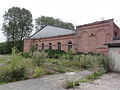
Bohéries Monastery


_abbaye_de_Boh%C3%A9ries_03_cloitre_devenu_usine_de_tussage.JPG)
Web links
Individual evidence
- ^ Entry in the Base Mérimée of the Ministry of Culture. Retrieved November 3, 2018 (French).