
Nampcelles-la-Cour
| Nampcelles-la-Cour | ||
|---|---|---|
|
||
| region | Hauts-de-France | |
| Department | Aisne | |
| Arrondissement | Vervins | |
| Canton | Vervins | |
| Community association | Thiérache du Center | |
| Coordinates | 48 ° 47 ' N , 4 ° 0' E | |
| height | 122-207 m | |
| surface | 10.89 km 2 | |
| Residents | 118 (January 1, 2017) | |
| Population density | 11 inhabitants / km 2 | |
| Post Code | 02140 | |
| INSEE code | 02535 | |
_mairie.JPG) Mairie Nampcelles-la-Cour |
||

Nampcelles la Cour (until 1801 with the spelling Nampcelles ) is a French municipality with 118 inhabitants (at January 1, 2017) in the department of Aisne in the region of Hauts-de-France . It belongs to the Arrondissement of Vervins and the Canton of Vervins . Nampcelles-la-Cour is a member of the Thiérache du Center municipal association .
geography
The municipality of Nampcelles-la-Cour is located in the east of the Thiérache countryside , about halfway between the cities of Saint-Quentin and Charleville-Mézières and about 20 kilometers south of the border with Belgium. The neighboring municipalities are Plomion in the north, Bancigny in the northeast, Dagny-Lambercy in the east, Vigneux-Hocquet in the south, Braye-en-Thiérache in the west and Harcigny in the north-west. The municipal area is drained by the Brune River , which flows into the Vilpion 16 kilometers to the west . With the exception of a small portion of the Forêt Domaniale du Val de Saint-Pierre in the southwest, the 10.89 km² area of the municipality is free of forests.
Population development
| 1962 | 1968 | 1975 | 1982 | 1990 | 1999 | 2006 | 2017 | ||
|---|---|---|---|---|---|---|---|---|---|
| 199 | 188 | 167 | 152 | 141 | 133 | 135 | 118 | ||
| Sources: Cassini and INSEE | |||||||||
Attractions
- Saint Martin Church
- Memorial to the fallen of the First World War

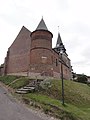
South side of St. Martin
Northeast side of St. Martin

Fallen memorial
_%C3%A9glise,_03.JPG)
_%C3%A9glise,_04.JPG)
_monument_aux_morts.JPG)
Economy and Infrastructure
14 farms are located in Nampcelles-la-Cour (cereal and vegetable growing, dairy farming, sheep and goat farming).
The D 61 trunk road from Hary to Brunehamel runs through the municipality of Nampcelles-la-Cour . In the small town of Vervins , 14 kilometers away, there is a connection to the RN 2 . Vervins is also the nearest train station on the La Plaine – Hirson line .
supporting documents
- ↑ toponym on cassini.ehess.fr
- ↑ Nampcelles-la-Cour on cassini.ehess.fr
- ↑ Nampcelles-la-Cour on insee.fr
- ↑ Farms on annuaire-mairie.fr (French)