Iron (Aisne)
| Iron | ||
|---|---|---|
|
|
||
| region | Hauts-de-France | |
| Department | Aisne | |
| Arrondissement | Vervins | |
| Canton | Guise | |
| Community association | Thiérache Sambre et Oise | |
| Coordinates | 49 ° 57 ′ N , 3 ° 40 ′ E | |
| height | 110-160 m | |
| surface | 9.51 km 2 | |
| Residents | 239 (January 1, 2017) | |
| Population density | 25 inhabitants / km 2 | |
| Post Code | 02510 | |
| INSEE code | 02386 | |
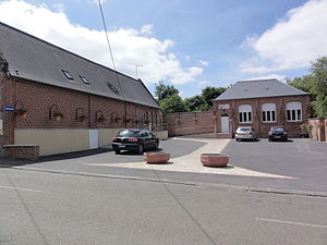
 Town Hall (Mairie) by Iron |
||
Iron is a French municipality with 239 inhabitants (as of January 1 2017) in the department of Aisne in the region of Hauts-de-France . It belongs to the Arrondissement of Vervins , the Canton of Guise and the municipal association Thiérache Sambre et Oise .
geography
Iron is located in the northern part of the Aisne department, around 47 kilometers from the prefecture of Laon and 32 km from the sub-prefecture of Saint-Quentin . The place is crossed from east to west by the river of the same name . Iron is surrounded by the neighboring communities of La Neuville-lès-Dorengt in the northwest, Dorengt in the northeast, Lavaqueresse in the east, Villers-lès-Guise in the southeast, Lesquielles-Saint-Germain in the southwest, Hannapes in the west and Vénérolles in the northwest.
Population development
| year | 1962 | 1968 | 1975 | 1982 | 1990 | 1999 | 2009 | 2015 |
| Residents | 332 | 300 | 276 | 287 | 284 | 225 | 220 | 244 |
| Source: Cassini and INSEE | ||||||||
Attractions
- Saint-Denis church


