
Hary (Aisne)
| Hary | ||
|---|---|---|
|
||
| region | Hauts-de-France | |
| Department | Aisne | |
| Arrondissement | Vervins | |
| Canton | Vervins | |
| Community association | Thiérache du Center | |
| Coordinates | 49 ° 47 ' N , 3 ° 56' E | |
| height | 112-190 m | |
| surface | 11.04 km 2 | |
| Residents | 208 (January 1, 2017) | |
| Population density | 19 inhabitants / km 2 | |
| Post Code | 02140 | |
| INSEE code | 02373 | |
_%C3%A9glise_(01).JPG) Saint-Corneille-et-Saint-Cyprien fortified church |
||

Hary is a French village with 208 inhabitants (at January 1, 2017) in the Aisne department in the region of Hauts-de-France (before 2016: Picardy ); it belongs to the arrondissement of Vervins and the Thiérache du Center municipal association founded in 1992 . The inhabitants are called Haryacois .
geography
The municipality Hary is located on Rivière Brune in the heart of their fortified churches known landscape Thiérache , about 20 kilometers southwest of Hirson and 33 kilometers northeast of Laon . In the north, the river Vilpion forms the municipal boundary . The almost forest-free municipal area is characterized by hills with large arable land. In addition to the eponymous village of Hary, Hary also includes the districts and hamlets of Rabouzy, Chaussée de Hary (partially) and Grande Feuillée .
Neighboring municipalities of Hary are Vervins in the north, Thenailles in the northeast, Braye-en-Thiérache in the southeast, Burelles in the south, Gronard in the west and Gercy in the northwest.
Population development
| year | 1962 | 1968 | 1975 | 1982 | 1990 | 1999 | 2007 | 2016 | |
| Residents | 343 | 292 | 214 | 206 | 180 | 200 | 225 | 215 | |
| Sources: Cassini and INSEE | |||||||||
Attractions
- Fortified church of Saint-Corneille-et-Saint-Cyprien with origins from the 12th century, Monument historique
- Ax vert . Hiking and cycling path along the former track bed of the disused railway line from Guise to Hirson
- Water tower in the Chaussée de Hary district
- Lavoir
- War memorial

Saint-Corneille-et-Saint-Cyprien fortified church
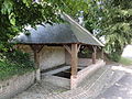
Lavoir

War memorial
_%C3%A9glise_(02).JPG)
_lavoir.JPG)
_monument_aux_morts.JPG)
Economy and Infrastructure
Hary is still dominated by agriculture. Ten farms operate dairy farming or mainly grow cereals and pulses.
The D966 highway runs through Hary from Reims to Vervins . The nearest train station is in the small town of Vervins, seven kilometers away, with connections to Hirson and Laon .
supporting documents
- ↑ Hary on cassini.ehess.fr
- ↑ Hary on insee.fr
- ^ Entry in the Base Mérimée of the Ministry of Culture. Retrieved November 28, 2018 (French).
- ↑ Farms in Hary on annuaire-mairie.fr (French)