Houry
| Houry | ||
|---|---|---|
|
|
||
| region | Hauts-de-France | |
| Department | Aisne | |
| Arrondissement | Vervins | |
| Canton | Vervins | |
| Community association | Thiérache du Center | |
| Coordinates | 49 ° 47 ' N , 3 ° 51' E | |
| height | 90-172 m | |
| surface | 3.48 km 2 | |
| Residents | 53 (January 1, 2017) | |
| Population density | 15 inhabitants / km 2 | |
| Post Code | 02140 | |
| INSEE code | 02384 | |
 Town hall of the municipality |
||
Houry is a French municipality with 53 inhabitants (at January 1, 2017) in the department of Aisne in the region of Hauts-de-France .
geography
The D37 département road runs through the village in the Vervins district in the canton of Vervins, southwest of Vervins . The river Brune runs south of the village .
In 1793 the place had 121 inhabitants. By 1836 the population rose to 160. It then fell over the long term until it was only 102 people in 1911. In 1921 it had risen again to 116, only to drop again shortly afterwards. After a temporary increase to 113 people in 1946, it then fell sharply. In 1982 only 49 people lived in the village and afterwards only recovered slightly. In 2009 the community had 63 residents.
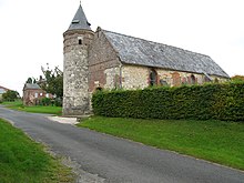
There is a historic fortified church in the village.
Population development
| year | 1962 | 1968 | 1975 | 1982 | 1990 | 1999 | 2007 | 2016 |
| Residents | 78 | 369 | 53 | 49 | 57 | 57 | 63 | 50 |
| Sources: Cassini and INSEE | ||||||||

