Hannapes
| Hannapes | ||
|---|---|---|
|
|
||
| region | Hauts-de-France | |
| Department | Aisne | |
| Arrondissement | Vervins | |
| Canton | Guise | |
| Community association | Thiérache Sambre et Oise | |
| Coordinates | 49 ° 58 ' N , 3 ° 38' E | |
| height | 100-185 m | |
| surface | 9.16 km 2 | |
| Residents | 318 (January 1, 2017) | |
| Population density | 35 inhabitants / km 2 | |
| Post Code | 02510 | |
| INSEE code | 02366 | |
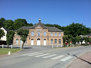
 Mairie Hannapes |
||
Hannapes is a French commune with 318 inhabitants (January 1, 2017) in the Aisne department of the Picardy region . It belongs to the Arrondissement of Vervins , the Canton of Guise and the municipal association Thiérache Sambre et Oise .
geography
The municipality of Hannapes is located in the Thiérache , 35 kilometers northeast of Saint-Quentin on the northern edge of the Aisne department at the confluence of the Iron in the Noirrieu and on the Sambre-Oise Canal , which follows the Noirrieu valley.
Neighboring municipalities of Hannapes are Vénérolles in the northeast, Iron in the southeast, Lesquielles-Saint-Germain in the south and Tupigny in the west and northwest.
history
Charles the Bald left the former royal property to his henchman and chronicler Nithard in 845 . The property later belonged to the Prüm Abbey , followed by the Lords of Le Nouvion-en-Thiérache and, in 1137, the Premonstratensian Abbey. In 1210 the abbey built a village. The lordship rights were transferred to the ducal family of the House of Guise . In 1462 Johann von Luxemburg took over the village after the castle had been destroyed by the English in 1423. In 1650 the village was taken by the Spanish. The first local chronicle was published on March 8, 1888.
In the course of history, the spelling of the place name has been changed several times. In the past we find Anapia , Hanapium , Henappe (on the Cassini map ), Hannape , Hannappes (this designation is still on the town hall and on the lock sign) and currently Hannapes on the town sign. The spelling differs from the place Hannappes in the Ardennes, only 60 kilometers away.
Population development
| year | 1962 | 1968 | 1975 | 1982 | 1990 | 1999 | 2007 | 2016 |
| Residents | 384 | 386 | 359 | 351 | 272 | 278 | 267 | 315 |
The population fluctuated a lot over the centuries. The largest number of inhabitants is recorded in 1861 with 1137 inhabitants. In 1766, 156 fires were counted in the place, i.e. dwellings, which corresponds to about 600 inhabitants. In 1795 a census of residents over 12 years was carried out, in which 455 people are recorded. A realistic projection of the total population at this point in time also corresponds to approximately 600 people. The social structure is typical for this time with numerous auxiliary and field workers, some weavers and spinners. There were also tailors, butchers, coopers, shoemakers, traders of various goods (tobacco, fabric, grain, fruits, horses, groceries), farriers, turners, a guesthouse operator, brewers, shepherds, upholsterers, carpenters, hauliers, innkeepers and agents other professions that were needed in every place, as well as a large farmer, a notary, a justice of the peace and a teacher. At the end of the 19th century there were 818 and in 1962 there were still 384 residents.
Attractions
The Church of St. John ( Église Saint-Jean ) originally dates from the 13th century and has remained almost unchanged since the 17th century. At the entrance to the church there is an approximately 2 × 1 meter stone tablet dedicated to the mayor Pierre François Moneuse (1762–1824). Hannapes has beautiful Thiérache-style houses, a brick and stone miller's house, and three mills.

