
Wiège-Faty
| Wiège-Faty | ||
|---|---|---|
|
||
| region | Hauts-de-France | |
| Department | Aisne | |
| Arrondissement | Vervins | |
| Canton | Marle | |
| Community association | Thiérache du Center | |
| Coordinates | 49 ° 53 ' N , 3 ° 43' E | |
| height | 103-159 m | |
| surface | 7.47 km 2 | |
| Residents | 200 (January 1, 2017) | |
| Population density | 27 inhabitants / km 2 | |
| Post Code | 02120 | |
| INSEE code | 02832 | |
 Mairie Wiège-Faty |
||

Wiège-Faty is a French commune of 200 inhabitants (at January 1, 2017) in the Aisne department in the region of Hauts-de-France (before 2016: Picardy ); it belongs to the Arrondissement Vervins and the municipality of Thiérache du Center . The inhabitants are called Wiègeois .
geography
The municipality of Wiège-Faty is located in the Thiérache region , about 25 kilometers west of Hirson and 39 kilometers north of Laon , on the left, southern bank of the upper Oise , which partially forms the northern municipal boundary. Except for small remains of alluvial forest in the north-west, the municipality is treeless and dominated by arable land. The community consists of the two eponymous villages Wiège with the town hall and Faty .
Neighboring communities of Wiège-Faty are Monceau-sur-Oise in the north, Malzy in the northeast (point of contact), Romery in the east, Le Sourd in the southeast, Colonfay in the south and Flavigny-le-Grand-et-Beaurain in the west.
history
Wiège was founded in 1142 from the Sainte-Hunegonde monastery in Homblières . The fortified castle of Wiège, in which Joan of Arc should have been temporarily imprisoned, was besieged by the Count of Marle for three weeks in 1424 before he took it and destroyed it. During the Ancien Régime Wiège was part of the Bailiwick of Guise in the Diocese of Laon . For the year 1760 the following land use information has been handed down in Wiège:
- Total area 2,600 arpente , of which
- 100 Arpente gardens and meadows
- 260 Arpente forest
Before the French Revolution, there was a noble fortress in the village of Faty. In 1777 a paper factory was established in Faty.
Population development
| year | 1962 | 1968 | 1975 | 1982 | 1990 | 1999 | 2007 | 2016 |
| Residents | 343 | 292 | 214 | 206 | 180 | 200 | 225 | 208 |
| Source: Cassini and INSEE | ||||||||
Attractions
- Church of St. Martin in Wiège
- Fortified church of St. Martin in Faty
- Ax vert . Hiking and cycling path along the former track bed of the disused railway line from Guise to Hirson
- Water tower
- Lavoir
- several wells
- two oratorios

Church of St. Martin in Wiège, behind it remains of the castle park
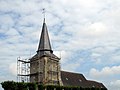
Tower restoration of the Church of St. Martin in Faty 2007

Lattice gate in front of the castle in Wiège.

Memorial plaque for the fallen of World War II

former Wiège-Faty - Romery station

Bike path on the former track bed in front of the station building


_plaque_mon._aux_morts_1940_Faty.JPG)
_Axe_vert,_ancienne_gare.JPG)

Economy and Infrastructure
Wiège-Faty is still dominated by agriculture. Eleven farms raise cattle or mainly grow cereals and pulses.
Transport links
The former Route nationale 360 (now the D360) runs through Wiège-Faty from Guise to Vervins . The nearest train station is in the small town of Vervins, 16 kilometers away, with connections to Hirson and Laon . Villers-Agron-Aiguizy on the A4 autoroute . The next motorway junction is in Gauchy, 35 kilometers away, on the A34 autoroute .
Personalities
- Albéric Loqueheux (1903–1985), racing car driver
supporting documents
- ↑ History abstract on genealogie-aisne.com (French)
- ↑ Farms in Wiège-Faty on annuaire-mairie.fr (French)