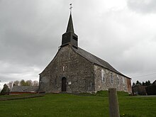
Rocquigny (Aisne)
| Rocquigny | ||
|---|---|---|
|
|
||
| region | Hauts-de-France | |
| Department | Aisne | |
| Arrondissement | Vervins | |
| Canton | Vervins | |
| Community association | Thiérache du Center | |
| Coordinates | 50 ° 1 ′ N , 3 ° 59 ′ E | |
| height | 157-231 m | |
| surface | 10.99 km 2 | |
| Residents | 361 (January 1, 2017) | |
| Population density | 33 inhabitants / km 2 | |
| Post Code | 02260 | |
| INSEE code | 02650 | |
 Rocquigny town hall (Mairie) |
||
Rocquigny is a French municipality with 361 inhabitants (as of January 1 2017) in the department of Aisne in the region of Hauts-de-France (before 2016: Picardie ). It belongs to the arrondissement Vervins , the canton Vervins (until 2015: canton La Capelle ) and the municipality association Thiérache du Center .
geography
Rocquigny is surrounded by the neighboring communities Clairfontaine in the south, La Flamengrie in the west and from the region Hauts-de-France , Nord , located communities Etroeungt in the northwest, Féron in the Northeast and Wignehies the east.
history
The old Cistercian Abbey of Montreuil-les-Dames was on the territory of Rocquigny until 1657 .
Population development
| year | 1962 | 1968 | 1975 | 1982 | 1990 | 1999 | 2006 | 2015 |
| Residents | 431 | 438 | 426 | 407 | 424 | 392 | 395 | 368 |
| Source: Cassini and INSEE | ||||||||
Attractions
- Sainte-Geneviève church
Web links
Commons : Rocquigny - collection of images, videos and audio files

