
La Bouteille
| La Bouteille | ||
|---|---|---|

|
|
|
| region | Hauts-de-France | |
| Department | Aisne | |
| Arrondissement | Vervins | |
| Canton | Vervins | |
| Community association | Thiérache du Center | |
| Coordinates | 49 ° 52 ′ N , 3 ° 58 ′ E | |
| height | 125-223 m | |
| surface | 19.0 km 2 | |
| Residents | 486 (January 1, 2017) | |
| Population density | 26 inhabitants / km 2 | |
| Post Code | 02140 | |
| INSEE code | 02109 | |
_mairie.JPG) Town Hall (Mairie) of La Bouteille |
||

La Bouteille is a French municipality with 486 inhabitants (at January 1, 2017) in the department of Aisne in the region of Hauts-de-France . It belongs to Arrondissement Vervins , the Canton of Vervins and the community association Thiérache du Center .
geography
La Bouteille is surrounded by the neighboring communities of Landouzy-la-Cour in the south-east, the canton capital Vervins in the south-west, Fontaine-lès-Vervins in the west, Étréaupont in the north-west and north and the communities of Ohis in the canton of Hirson in the north-east and Origny-en-Thiérache in the East.
history
The place and its name go back to the establishment of a bottle factory in 1540.
Population development
| 1962 | 1968 | 1975 | 1982 | 1990 | 1999 | 2009 | 2015 | |
|---|---|---|---|---|---|---|---|---|
| 656 | 633 | 549 | 514 | 502 | 508 | 506 | 493 | |
| Source: Cassini and INSEE | ||||||||
Attractions
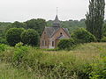
- Notre-Dame fortified church , built in the 16th century, monument historique since 1995
- Foigny monastery , former Cistercian abbey

Notre-Dame church
Memorial chapel of Floigny Abbey
_%C3%A9glise_(01).JPG)
_en_souvenir_de_l%27abbaye_de_Floigny_01.JPG)
Web links
Commons : La Bouteille - collection of images, videos and audio files
Individual evidence
- ^ Entry in the Base Mérimée of the Ministry of Culture. Retrieved December 6, 2018 (French).