Horný bar
| Horný bar | ||
|---|---|---|
| coat of arms | map | |

|
|
|
| Basic data | ||
| State : | Slovakia | |
| Kraj : | Trnavský kraj | |
| Okres : | Dunajská Streda | |
| Region : | Podunajsko | |
| Area : | 11.775 km² | |
| Residents : | 1,231 (Dec. 31, 2019) | |
| Population density : | 105 inhabitants per km² | |
| Height : | 121 m nm | |
| Postal code : | 930 33 | |
| Telephone code : | 0 31 | |
| Geographic location : | 47 ° 57 ' N , 17 ° 28' E | |
| License plate : | DS | |
| Kód obce : | 501603 | |
| structure | ||
| Community type : | local community | |
| Structure of the municipality: | 2 parts of the community | |
| Administration (as of November 2018) | ||
| Mayor : | Štefan Bodó | |
| Address: | Obecný úrad Horný Bar č. 184 930 33 Horný Bar |
|
| Website: | www.hornybar.sk | |
| Statistics information on statistics.sk | ||
Horný Bar (until 1927 "Felbár" in Slovak; Felbár in Hungarian ) is a municipality in southwest Slovakia with 1231 inhabitants (as of December 31, 2019). It belongs to the Okres Dunajská Streda , part of the Trnavský kraj .
geography
The municipality is located in the central part of the Great Schüttinsel , part of the Slovak Danube lowlands . The municipal area is deforested, flat and separated from the old river bed of the Danube by the power station channel of the Gabčíkovo hydroelectric power station . The center of the village lies at an altitude of 121 m nm and is 15 kilometers from Šamorín and 17 kilometers from Dunajská Streda .
Administratively, the municipality is divided into parts of Horný Bar and Šúľany (incorporated in 1960; in Hungarian Süly ).
Neighboring municipalities are Blatná na Ostrove and Holice in the north, Jurová in the east, Trstená na Ostrove in the southeast, Bodíky in the south, Vojka nad Dunajom in the west and Rohovce in the northwest.
history
The place was first mentioned in writing in 1245 as Baar and is probably derived from the Hungarian name Baár . Until 1269 it belonged to the estate of the Pressburg Castle ; in the same year he came to the possession of the Comes Bood . The Amadé family lived here for a long time and owned a country castle in the village. Other important owners were Illesházy , Istvánffy and Boboky , and in the 19th century Zichy . In 1828 there were 98 houses and 713 inhabitants.
Until 1919, the place in Pressburg County belonged to the Kingdom of Hungary and then came to Czechoslovakia or now Slovakia. 1938-45 he was again in Hungary due to the First Vienna Arbitration .
In 1960 the neighboring municipalities of Šúľany and Bodíky became part of the municipality of Horný Bar; In 1988 Bodíky split off again.
population
According to the 2011 census, there were 1236 inhabitants in Horný Bar, including 965 Magyars, 247 Slovaks, six Czechs, two Bulgarians and two Jews and one Moravian. 13 residents did not answer. 1,049 residents committed to the Roman Catholic Church, 15 residents to the Reformed Church, nine residents to the Evangelical Church AB, two residents each to the Evangelical Methodist Church and two residents to the Congregational Church and one resident each to the Greek Catholic Church and the Jewish community; four residents professed a different denomination. 113 residents had no denomination and 40 residents had no denomination.
Buildings
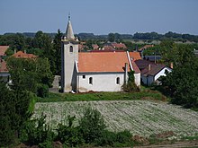
- Roman Catholic St. Stephen's Church in baroque-classicist style from 1778, built in place of the older Gothic church
- Roman Catholic Church of St. Anne in the district of Šúľany in Gothic style from the 14th century, in the 18th century partly decorated in Baroque style
Individual evidence
- ↑ 2011 census by ethnicity (Slovak) ( Memento from October 6, 2014 in the Internet Archive )
- ↑ 2011 census by denomination (Slovak) ( Memento from September 7, 2012 in the Internet Archive )
Web links
- Entry on e-obce.sk (Slovak)

