
Kastl (Lauterachtal)
| coat of arms | Germany map | |
|---|---|---|

|
Coordinates: 49 ° 22 ' N , 11 ° 41' E |
|
| Basic data | ||
| State : | Bavaria | |
| Administrative region : | Upper Palatinate | |
| County : | Amberg-Sulzbach | |
| Height : | 475 m above sea level NHN | |
| Area : | 64.87 km 2 | |
| Residents: | 2502 (Dec. 31, 2019) | |
| Population density : | 39 inhabitants per km 2 | |
| Postal code : | 92280 | |
| Area code : | 09625 | |
| License plate : | AS, BUL , ESB , NAB , SUL | |
| Community key : | 09 3 71 132 | |
| Market structure: | 37 districts | |
Market administration address : |
Marktplatz 1 92280 Kastl |
|
| Website : | ||
| Mayor : | Stefan Braun ( CSU ) | |
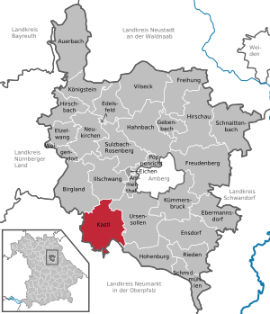
| Location of the Kastl market in the Amberg-Sulzbach district | ||
  |
||

Kastl is a market in the Upper Palatinate district of Amberg-Sulzbach, around 50 kilometers east of Nuremberg and around 70 kilometers northwest of Regensburg .
geography

Geographical location
Markt Kastl is located in the eastern part of the Franconian Alb on the Lauterach , a tributary of the Vils and in the middle between Amberg and Neumarkt in the Upper Palatinate , almost exactly 20 kilometers away. The 587 meter high Brennersberg is located in the local area. The agitated landscape of the community lies in the Northern Kuppenalb. The structurally rich forest landscape was classified as Germany's landscape worthy of protection (code number: 8101). The Lauterach valley is also known as the Tuscany of the Upper Palatinate because of its natural beauty .
Natural allocation
In terms of natural space , Kastl belongs to the main unit Middle Franconian Alb , which, according to the natural spatial structure of Germany (according to Meynen / Schmithüsen et al.), Is part of the main unit group Franconian Alb .
Community structure
Kastl has 39 districts:
Neighboring communities
The neighboring communities of Kastl include: Lauterhofen , Velburg , Hohenburg , Ursensollen and Birgland .
Geology and soil
geology

The Kastl market is located in the south-west of Germany . The White Jura (Malm) is the determining geological group, it was formed during the period of the Lower Cretaceous . In the Cretaceous period, deeply incised valley systems such as the Lauterach valley and the valley of the Mühlhauser Bach formed, and karstification processes resulted in a varied and profiled karst landscape with a few caves. Layers from the Frankenalb formation of the Weißjura group dominate the landscape of the community. Reef dolomite is the defining geological unit. The massive dolomite stone partially contains fossils . South of Wolfsfeld, the north face of the Brennersberg is designated as a geotope (no. 371R033). The Brennersberg has a height of 580 m above sea level at this point . NN on. The bench-top dolomite is located in the transition to the reef dolomite. The dark reef dolomite rock of the Malm Delta forms a 10 to 15 m wide base on which leveling with light dolomite rock from layers of the Kimmeridgium , the so-called Malm Epsilon, rise up. In the reef dolomite, many fossils are arranged in the form of light-colored pebbles. The pebbly material goes back to organisms that carry opal skeletons. In addition, protective rock formations from the Danubian chalk group have developed in the karst crevices. In the process, sands and clays were deposited in the karst hollow forms in the Paleozoic to Mesozoic Era and locally form an overburden . There are Quaternary valley fillings in the Lauterach Valley and along the Mühlhauser Bach . Colluvial fillings cover the dry valleys of the karst landscape. In the Young Holocene , colluvia from the area around the valleys were entered.
ground
The typical karst soil types Rendzina and brown earth-Rendzina have developed on the crests and hills . Brown earth soils occur in the flatter valley areas. In the Lauterach valley, fertile Vega soils made up of the soil types silt and loam (floodplain sediment) dominate.
climate
Kastl is located in the cool, temperate climate zone and has a humid climate . The landscape of the municipality is located in the transition area between the humid Atlantic and the dry continental climate . After the climate classification of Köppen / Geiger Kastl belongs to the temperate warm rainy climate (Cfb climate). The mean air temperature of the warmest month remains below 22 ° C and that of the coldest month above -3 ° C. The karst landscape warms up faster in spring and autumn than the meadows of the Lauterach valley.
Land use
| use | Hectares |
|---|---|
| Housing area | 57 |
| Industrial and commercial space | 11 |
| traffic area | 249 |
| Forest area | 3159 |
| Agricultural area | 2674 |
| Area of water | 19th |
| total area | 6488 |
Due to its location and structure, Markt Kastl is a rural municipality. This is reflected in the land use. Forests, meadows and arable land (vegetation areas) together make up 93.3 percent of the municipal area, as the land use table shows. The municipality has a very high proportion of forest areas, which is 48.7 percent and thus makes up half of the municipality area of Kastl. The agriculturally used areas also take up a large share of the area at 41.2 percent. By contrast, the share of residential building space is only 0.9 percent. Industrial and commercial areas make up a comparatively small share of 0.2 percent of the municipal area. The traffic area share is 3.8 percent.
Protected areas
Natura 2000 site
The structurally rich beech and mixed beech forests on the dolomite peaks and limestone sites of the municipal area, which are partly intermingled with lime grasslands ( ecotones ), were reported to the European Commission as parts of the European protected area Forests in the Upper Palatinate Jura ( FFH area , No. 6535-371 ) . The protected forest habitats with the surrounding open land rich in bases take on an important stepping stone function in the Natura 2000 network of the northern Franconian Alb. The 801 hectare FFH (Fauna-Flora-Habitat) area comprises several sub-areas and has some of the largest orchid occurrences of the yellow lady's slipper ( Cypripedium calceolus ) in the natural area of the Franconian Alb . The woodruff beech forests (Asperulo-Fagetum) and Central European orchid-lime-beech forests (Cephalanthero-Fagion) with a high proportion of old and dead wood are under special protection and should be further developed due to their nature conservation importance. The very endangered bat species greater horseshoe bat (Rhinolophus ferrumequinum) uses the forest areas in the municipal area for hunting and as a flight corridor between the day quarters and foraging habitats. The forest and woody areas are in close functional interrelationship with the occurrence in Hohenburg , Germany's last bat colony of the great horseshoe bat. In addition, in the FFH area forests in the Upper Palatinate Jura there are other protected bat species such as pug bat (Barbastella barbastellus) and great mouse- eared bat (Myotis myotis) . The Natura 2000 area also has uncut habitat complexes consisting of spawning and land habitats of the northern crested newt ( Triturus cristatus ), an endangered amphibian species .
Landscape protection area
_NP_Hirschwald.JPG)
Large parts of the municipality are protected as a landscape protection area. The designation of the Lauterachtal landscape protection area with the valleys of the Hausener and Utzenhofener brooks and the Jura area between Kastl and Utzenhofen took place in 1965. The 4682 hectare protected area is mainly located in the south of the Kastl market (LSG00121.09).
Natural park
The extensive Deer Forest Nature Park covers a large part of the Kastl market (identifier: NP-00017). Only the northern districts of the community - such as Dettnach and Wolfsfeld - are not part of the 27,760 hectare nature park . The protected landscape extends far beyond the municipal boundaries.
Natural forest reserve
The Hainsimsen-Buchenwald (Luzulo-Fagetum) in the area of the Herrenberg north of Pattershofen was designated as a natural forest reserve by the Bavarian State Ministry for Food, Agriculture and Forests in 2017 and thus removed from forest management. The reserve is located on an elongated Jura ridge running from west to east at an altitude of 510 to 559 m above sea level. NN . The Herrnberg natural forest reserve covers 48.2 hectares and belongs to the Burglengenfeld forestry operation . It is part of the Bavarian forest biotope network and serves to safeguard the biodiversity of the Bavarian forests. The reserve is located within the FFH area forests in the Upper Palatinate Jura. Gap old beech wood with dense natural regeneration from red beech (Fagus sylvatica) characterize the forest stands of the Herrenberg, which are valuable in terms of nature conservation. Unnatural were out of the woods spruce stocks (Pinus sylvestris) away, which by the bark beetle (Scolytinae) were already at risk. Only pines (Pinus sylvestris), firs (Abies) and larches (Larix decidua) were left as conifers in the mixed forest and left to succession . Younger groups consisting of sycamore maples ( Acer pseudoplatanus ) with numerous linden trees (Tilia) and individual black alders ( Alnus glutinosa ) as well as willow trees ( Salix caprea ) are found on more humid locations in the northeast of the reserve .
history
middle Ages

Over the centuries there have been different spellings for the place name, such as Castel or Kastel. The first written mention of Kastl comes from the year 1102 and the place name was Castellum. The Latin term castellum stands for fort, fortress or hill. In 1109 the place was called Castellense monasterium and indicates a monastery. The place name refers to an early medieval castle that was converted into a Benedictine monastery between 1098 and 1103 by the noble free Otto and Hermann von Kastl, Count Berengar I von Sulzbach and the Diepoldingen Margravine Luitgart . The monastery is the oldest Benedictine monastery in Northern Gau and was the house monastery of the influential Count of Sulzbach until 1188. It was considered one of the most important reform monasteries of the Hirsau reform movement in southern Germany during the 12th century. The church, which is important in terms of art history and architecture, is dedicated to St. Consecrated Peter. In the High Middle Ages, the monastery can be considered one of the cultural centers of today's Upper Palatinate. In 1323 the place received market rights with important proprietary rights from Ludwig the Bavarian , whose daughter Anna died in Kastl as a toddler and - preserved as a mummy - can be viewed in the monastery church (in 2013 the body was cleaned and reburied in a nitrogen-filled shrine for six months , to reduce moisture).
Early modern age
The monastery existed until secularization in 1803, belonged to the Jesuits during the Reformation and after the abolition of the Jesuit order in Bavaria in 1782 to the Order of St. John and the Order of Malta , to which it had been given by the Bavarian Elector Karl Theodor. The place was part of the Electorate of Bavaria and formed a closed Hofmark , the seat of which was the monastery.
20th century
Until 1929 Kastl was the center of the district with a regional court and tax office. Before that, at the latest with the discussion about the construction of the railway lines, Kastl had come into focus of the different interests in Amberg and Neumarkt.

So there had been considerations to run the Nuremberg – Regensburg railway via Kastl. It was finally realized via Neumarkt. In return, a rail link between Amberg and Neumarkt should be built. Finally (inauguration in 1903) only a local railway (branch or suction railway ) was built from Amberg to Lauterhofen . With the construction of the first highways, Kastl should be taken into account again for the connection from Nuremberg to Regensburg. It was not completed because of the Second World War . The ashlars for bridge structures were already stored in Hainthal (remnants of them today at the outdoor pool car park) and the humus holdings on the plateaus above the monastery castle. A few decades later the autobahn was routed through Neumarkt.

The district function was given to Neumarkt idOPf with the administrative reform in 1929. from, the tax office function to Amberg. “On December 31st, 1930 the local court was dissolved, an almost unbearable bloodletting. The imposing monastery castle on the Jura heights now stood desolate and abandoned, waiting for a new task. One tried again to win a religious community to settle. That didn't work either. The city of Regensburg built a school camp for its school children ”. In 1935 a female labor service joined them. "Approx. 50 girls had to do their six-month labor service, where they were deployed with large families and farms. The closed accommodation provided a National Socialist education ”(cf. Mosner's Heimatbücherl). In August and September 1942, according to research by those responsible for the Hungarian grammar school, "kidnapped children of Slovenian resistance fighters partisans who were forcibly separated from their families in retaliation " were housed in the castle by the National Socialist rulers . "Both institutions were closed at the end of the war. The expulsion of the Germans from areas in the East now made it necessary to set up a refugee camp within the historic walls. Six to eight hundred and more displaced persons found temporary emergency rooms" (ibid.). From 1958 to 2006, the European-Hungarian grammar school with an attached boarding school was located in the historical rooms of the monastery .
District affiliation
With the regional reform , the Kastl market was assigned to the enlarged district of Amberg on July 1, 1972, which was given the name of Amberg-Sulzbach district on May 1, 1973 .
Incorporations
On July 1, 1972, Kastl was expanded to include parts of the municipalities of Brunn, Hausen, Winkl and Wolfsfeld. Pfaffenhofen and Utzenhofen were added on May 1, 1978.
Population development
The population development of the Kastl market was slightly positive between 1840 and 1939. In 1840 there were still 2003 citizens living in Kastl, in 1939 there were already 2,258 inhabitants. After the Second World War there was a strong influx of people into the community and in 1950 the market had the highest population with 3069 people. After that, the population development declined. Between 1961 and 1970 the population rose again to 2,860. By 2013, there was then a noticeable decrease in population to 2395 inhabitants. In the following years there was moderate population growth. However, from 1987 to 2016, Kastl showed a decline in the proportion of people under the age of 18. In parallel to this development, the proportion of people over 50 and over 65 increased significantly. The over 50-year-olds made up almost half of Kastl's population with 48.9 percent in 2016. A quarter of the community's population was over 65 years old in 2016. In 1987 this age group made up only one eighth of the population.
Between 1988 and 2018 the population decreased from 2,615 to 2,482 by 133 inhabitants or 5.1%.
| year | 1840 | 1871 | 1900 | 1925 | 1939 | 1950 | 1961 | 1970 | 1987 | 2007 | 2008 | 2009 | 2010 | 2011 | 2012 | 2013 | 2014 | 2015 | 2016 |
|---|---|---|---|---|---|---|---|---|---|---|---|---|---|---|---|---|---|---|---|
| Residents | 2003 | 2025 | 2051 | 2162 | 2268 | 3069 | 2667 | 2860 | 2588 | 2544 | 2522 | 2490 | 2467 | 2407 | 2410 | 2395 | 2428 | 2440 | 2447 |
Source: Population figures from the Bavarian State Office for Statistics
politics
Municipal council
The municipal council has 14 members. Another member and chairman of the municipal council is the mayor. In the local elections on March 15, 2020, 1,515 of the 2,091 residents eligible to vote in the municipality of Kastl exercised their right to vote, bringing the turnout to 72.45%.
mayor
Stefan Braun of the CSU has been the first mayor since May 2002 . In the local elections on March 15, 2020, he was re-elected with 80.32% of the vote.
coat of arms
Blazon : "Six in blue, three silver heraldic lilies set two to one."
Foundation of the coat of arms: The coat of arms has been used since around 1400 in memory of the Counts of Kastl-Habsberg and Sulzbach, the founders of the Benedictine monastery in Kastl, and it has been officially handed down since 1475 in the form of a seal of the monastery court, which showed the six heraldic lilies.
The six girdled heraldic lilies symbolize stylized irises .
partnership
Since 2008 there has been a partnership with the southern Hungarian town of Érsekcsanád.
Architectural monuments
Economy and Infrastructure
tourism
Kastl has been focusing on tourism since the 1950s. That is why the Schweppermannspiel was invented in the early 1950s , an amateur play in memory of Seyfried Schweppermann . The advertising association Amberg-Vils-Lauterachtal was founded with the strong participation of chancellors . The Deer Forest Nature Park , to which the landscape protection areas of Kastl belong, has existed since 2006 , and since 2008 Kastl has been the northernmost stage on the “ Jurasteig ” hiking trail that has won several awards in a European comparison . There is also an outdoor pool in Kastl - in addition to a BRK retirement home , some medium-sized companies (including a global manufacturer of machines for assembling circuit boards), numerous craft businesses and a rapeseed oil press .
energy
On the 587 meter high Brennerberg went in January 2012, a wind turbine of the type Vestas V112 3 MW power, 140 m hub height and 112 m rotor diameter in operation, which was the highest wind power plant in Bavaria in the completion.
education
In February 2008 a private investor rented the premises of the Klosterburg from the Free State of Bavaria in order to set up a college to prepare for studying at international universities. The elementary school ( primary and secondary school ) built in 1962 is located right next to the monastery building .
In 2018, a branch of the Sulzbach-Rosenberg department of the University for Public Service in Bavaria (based in Munich ) was under construction on the Klosterburg.
Sons of the place
- Peter von Kastl (around 1400), Benedictine monk, translator of Boëthius' Consolation of Philosophy
- August Holler (1835–1904), botanist
- Georg Widenbauer (1875–1960), local history researcher, honorary citizen of Kastl
- Ambrosius Hiltl (1877–1969), founder of the oldest vegetarian restaurant in the world
- Alfred Pöllath (1916–1996), politician
- Alfons Riedl (1937–2008), Roman Catholic clergyman and pacifist moral theologian
- Helmut Geist (* 1958), geographer
Trivia
Part of the feature film Whoever believes will be blessed was shot in the center of Kastl.
literature
- Heribert Batzl: History of the market town of Kastl. Ed. Marktgemeinde Kastl, 1984
- Xaver Mosner's Chancellor Heimatbücherl excerpts
Individual evidence
- ↑ "Data 2" sheet, Statistical Report A1200C 202041 Population of the municipalities, districts and administrative districts 1st quarter 2020 (population based on the 2011 census) ( help ).
- ↑ Landscape profile: 8101 Northern Kuppenalb and Vilsplatten. Federal Agency for Nature Conservation, March 1, 2012, accessed on January 5, 2019 .
- ↑ Nature conservation assessment of the landscapes in Germany. (PDF) Federal Agency for Nature Conservation (BfN), November 2011, accessed on January 13, 2019 .
- ^ Bavarian network for cyclists: Lauterachtal cycle path. Bavarian State Ministry for Housing, Building and Transport, accessed on January 15, 2019 .
- ↑ Map of the main natural space units and natural space units in Bavaria. (PDF) Bavarian State Office for the Environment, accessed on January 5, 2019 .
- ^ Municipality of Kastl in the local database of the Bavarian State Library Online . Bayerische Staatsbibliothek, accessed on July 28, 2020.
- ^ Geological map of Bavaria 1: 500,000. Bavarian State Office for the Environment, accessed on January 5, 2019 .
- ↑ The landscape and its natural features. (PDF) Amberg-Sulzbach district, Amberger Zeitung print, February 1978, accessed on January 5, 2019 .
- ↑ a b c Digital geological map of Bavaria 1: 25,000 (dGK25). Bavarian State Office for the Environment (LfU), accessed on January 5, 2019 .
- ↑ Applied geology: north face of the Brennersberg SSW von Wolfsfeld. (PDF) Bavarian State Office for the Environment (LfU), January 5, 2019, accessed on January 5, 2019 .
- ↑ Overview soil map of Bavaria 1: 25,000. Bavarian State Office for the Environment, accessed on January 5, 2019 .
- ↑ Climate. Climate-Data.org, accessed January 5, 2019 .
- ↑ a b c Municipal Statistics 2017: Markt Kastl 09 371 132. (PDF) Bavarian State Office for Statistics, January 31, 2018, accessed on January 6, 2019 .
- ↑ Bayer Atlas: Fauna-Flora-Habitat areas. Bavarian State Office for the Environment (LfU), accessed on January 5, 2019 .
- ↑ a b c d NATURA 2000 Bavaria Area-related specification of the conservation objectives. (PDF) Bavarian State Chancellery, February 19, 2016, accessed on January 5, 2019 .
- ↑ 6535-371 Forests in the Upper Palatinate Jura (FFH area). Published by the Federal Agency for Nature Conservation . Retrieved February 7, 2019.
- ↑ LBV project Great Horseshoe Bat, Germany's most threatened bat. State Association for Bird Protection in Bavaria eV (LBV), accessed on January 5, 2019 .
- ↑ BayernAtlas: Landscape protection areas. Bavarian State Office for the Environment, accessed on January 12, 2019 .
- ↑ Green list of landscape protection areas in the Upper Palatinate. (PDF) Bavarian State Office for the Environment, December 31, 2017, accessed on January 12, 2019 .
- ↑ 2018 United Nations List of Protected Areas of Germany Information extracted from the July 2018 WDPA release. ProtectedPlanet, accessed January 12, 2019 .
- ↑ BayernAtlas: Nature parks. Bavarian State Office for the Environment, accessed on January 13, 2019 .
- ↑ BAVARIAN STATE FORESTS INCREASE “PRIME FOREST”. Bayerische Staatsforsten AöR, May 4, 2017, accessed on January 13, 2019 .
- ↑ a b Forest is now a reserve. Onetz, May 5, 2017, accessed January 13, 2019 .
- ↑ Walter Keitel: What do we do without in natural forest reserves? (PDF) Bavarian State Institute for Forests and Forestry, accessed on January 13, 2019 .
- ↑ a b c d Overview of the natural forest reserves in the Upper Palatinate. Bavarian State Institute for Forests and Forestry, accessed on January 13, 2019 .
- ↑ Wolf-Armin Freiherr von Reitzenstein: Lexicon of Bavarian Place Names: Origin and Meaning. Upper Bavaria, Lower Bavaria, Upper Palatinate . CH Beck, Munich 2006, ISBN 3-406-55206-4 , p. 132 .
- ^ History of the A3 motorway
- ^ Wilhelm Volkert (ed.): Handbook of Bavarian offices, communities and courts 1799–1980 . CH Beck, Munich 1983, ISBN 3-406-09669-7 , p. 533 .
- ^ Federal Statistical Office (ed.): Historical municipality directory for the Federal Republic of Germany. Name, border and key number changes in municipalities, counties and administrative districts from May 27, 1970 to December 31, 1982 . W. Kohlhammer GmbH, Stuttgart and Mainz 1983, ISBN 3-17-003263-1 , p. 640 .
- ↑ Results of local elections 2020. OK.VOTE, March 15, 2020, accessed on May 16, 2020 .
- ↑ Results of local elections 2020. OK.VOTE, March 15, 2020, accessed on May 16, 2020 .
- ↑ Results of local elections 2020. OK.VOTE, March 15, 2020, accessed on May 16, 2020 .
- ↑ a b Emma Mages: House of Bavarian History: MARKT KASTL. Bavarian State Ministry for Science and Art, House of Bavarian History, accessed on January 6, 2019 .
- ↑ Partnership becomes friendship. Onetz, December 12, 2018, accessed January 6, 2019 .
- ↑ Helmut Geist (2019): The Jurasteig from a local landscape perspective. The Upper Palatinate 107 (4), p. 219.
- ↑ Schweppermannsbote der Marktgemeinde Kastl ( page no longer available , search in web archives ) Info: The link was automatically marked as defective. Please check the link according to the instructions and then remove this notice. (PDF; 3.4 MB). Retrieved March 20, 2012.
- ↑ Great expectations in wind power . In: Nordbayern.de , January 30, 2012. Accessed March 20, 2012.
- ↑ Construction board on the monastery castle, seen in 2018
Web links
- Market Kastl
- Entry on the coat of arms of Kastl (Lauterachtal) in the database of the House of Bavarian History
- Aerial view of Kastl
- Aerial views of the market
- Find of the monastery castle Kastl
- Kastl (Lauterachtal): Official statistics of the LfStat

Ammerthal | Auerbach in the Upper Palatinate | Birgland | Ebermannsdorf | Edelsfeld | Ensdorf | Etzelwang | Freedom | Freudenberg | Give Bach | Hahnbach | Hirschau | Hirschbach | Hohenburg | Illschwang | Kastl | Koenigstein | Kümmersbruck | Neukirchen near Sulzbach-Rosenberg | Poppenricht | Vineyards | Schmidmühlen | Schnaittenbach | Sulzbach-Rosenberg | Ursensollen | Vilseck | Weigendorf
Unregulated areas: oaks
Aicha | Allmannsfeld | Appesloh | Aumühle | Bärnhof | Brünnthal | Deinshof | Dettnach | Drahberg | Wing book | Freischweibach | Gaishof | Giggelsberg | Guttenberg | Haid | Hainhof | Half mill | Hellberg | Hohengrund | Kastl | Lauterach | Mennersberg | Mulhouse | Oberfeld | Pattershofen | Pfaffenhofen | Reusch | Dir | Sankt Lampert | Suction trenches | Blackness | Umelsdorf | Utzenhofen | Wolfersdorf | Wolfsfeld | Zapfl | Brick hut