
Kitzbühel Alps
| Kitzbühel Alps | |
|---|---|
 Overview map of the Kitzbühel Alps |
|
| Highest peak | Kreuzjoch ( 2558 m above sea level ) |
| location | Tyrol , Salzburg |
| Classification according to | AVE 34 |
| Coordinates | 47 ° 26 ' N , 12 ° 20' E |
The Kitzbühel Alps ( SOIUSA : Tiroler Schieferalpen ) are a mountain group in the Eastern Alps and part of the western slate zone ( Grauwackenzone ) in the Austrian federal states of Tyrol and Salzburg , with the Tyrolean share accounting for around two thirds. The east-west extension is about 80 km, the width 25–35 km. The highest peak is the Kreuzjoch in the southwest at 2558 m above sea level. A. To the east, the summit floor sinks to 2300 to 2000 m.
The Kitzbühel Alps are ideal for hiking and skiing. Rugged mountain forms are largely absent. There are some larger ski areas in both the Tyrolean and Salzburg regions . A geologically related continuation in the east are the Dienten mountains . The Pinzgauer Höhenweg runs through both mountains in an east-west direction , numerous ski routes and the Saalachtaler Höhenweg through the Kitzbühel Alps .
Location and landscape
The Kitzbühel Alps occupy the area between the Zillertal in the west and Lake Zell in the east. To the south, the Kitzbühel Alps are separated from the Venediger Group by the Gerlos Pass and the adjoining Salzach Valley . The boundary follows the Salzach Valley to Bruck , where it turns north via Zell am See and runs with the Saalach to Saalfelden . The northern border runs from east to west from the Saalfelden basin over the valley of the Leoganger Ache to the Grießen pass , from there over Pillerseetal , Leukental and Sölllandl to Wörgl and Kufstein . The north-western border is formed by the Inn valley between Wörgl and Jenbach .
The Kitzbühel Alps have been a popular filming location for feature films, especially Heimatfilme , since 1906 ; so far, over seventy films and series from various genres have been made.
Salzach vulture, 2469 m

View from the Salzachgeier over the Kelchsauer Alps

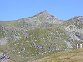
Spielberghorn from the east


Neighboring mountain groups
The Kitzbühel Alps border the following other mountain groups in the Alps:
- Kaiser Mountains (in the north)
- Loferer Steinberge (in the northeast)
- Leoganger Steinberge (in the northeast)
- Salzburg Slate Alps (in the east)
- Glockner group (in the southeast)
- Granatspitzgruppe (in the south)
- Venediger Group (in the south)
- Zillertal Alps (in the southwest)
- Tux Alps (in the west)
- Rofan Mountains (in the northwest)
structure
The Kitzbüheler Alps are divided by the Kitzbüheler Ache into the Glemmtal Alps in the east (Salzburg) and the Kelchsauer Alps in the west.
geology
The Kitzbühel Alps belong to the Grauwackenzone and are largely made up of slate and phyllites . The mountain forms and cirques are predominantly gentle of low mountain range character , the mostly green slopes have numerous alpine meadows (Tyrolean grass mountains ). But there are also rock formations through limestone and dolomites , for example on the Großer Rettenstein.
In the western part of the Kitzbühel Alps, most of the valleys run in a north-south direction, but in the eastern part mostly east-west. The alpingeological reason for this is the striking longitudinal furrow of the Salzach Valley. This so-called Tauern North Rim Fault , also known as the SEMP Lineament , played an essential role in the unfolding of the Alps and still marks a striking landform - and rock boundary to the three-thousanders of the Hohe Tauern .
The western border of the mountain is less clear from a petrographic point of view, because there the transition to the Innsbruck quartz phyllites is fluid. In the north-west and north (Inntal near Schwaz , Brixental and Steinernes Meer), on the other hand, the difference between the softly folded slate and the limestone and dolomite rocks of the limestone Alps is striking.
The main rocks of the Kitzbühel Alps are divided into two groups according to age, of which the older ones probably come from the Ordovician . The deeper complex of the Wildschönau slate is not very differentiated and shows no fossils, but volcanic deposits. Above it are weakly metamorphic porphyroids up to 600 m thick (emerged from volcanic quartz porphyries and tuffs ), mainly in the west ( Hohe Salve , Hahnenkamm and Wildseeloder ).
Various slate horizons from the Silurian lie above the porphyroid , which often become clayey-sandy towards the top. In the vicinity of Kitzbühel (e.g. Kitzbüheler Horn) there are also Silurian limestone and to the west the gray, coarse-grained Schwaz dolomite , which merges into the Spielberg dolomite to the east as far as Leogang . Also represented is the post- Variscian with transgression rocks, red slate from the Rotliegend and mighty sandstones from the Permoskyth. All these stratification sequences of the Grauwackenzone were presumably - together with those of the Northern Limestone Alps - pushed from a deposit area far in the south to the northern edge of the Alps at the time of the Alpine Folding.
The highest mountains
The highest mountains in the Kitzbühel Alps are mostly located in the southwest corner and - compared to the mountains north and south - reach a rather modest height of a good 2500 m.
The highest mountains in the range are:
|
|
|
Alpine pastures, shelters, ski areas
The Kitzbühel Alps are used intensively for tourism. The Kitzbühel Alps tourism region ( St. Johann in Tirol , Kitzbühel and the surrounding area, Pillerseetal , Brixental , Wildschönau and Alpbach ) only includes the Tyrolean part of the geographical Kitzbühel Alps. Popular excursion mountains on the edge of the Inn Valley are the Pölven ( 1595 m ) and the Gratlspitz ( 1899 m ).
The famous ski area of Kitzbühel is located roughly in the middle of the mountains . The Saalbach-Hinterglemm ski circuit is located in the eastern part .
In addition to a myriad of managed alpine pastures and inns, there are also a large number of mountain huts run by the Alpine Club and private operators:
|
|
|
literature
- Freytag-Berndt Kitzbühel Alps and Pinzgau . Hiking map 1: 100,000 (sheet 38) and hut guide, Geografa Vienna-Innsbruck-Munich-Bozen.
Web links
Individual evidence
- ↑ http://www.karwendel-urlaub.de/ Umgebung/kitzbueheler-alpen/drehorte /
- ^ R. Oberhauser (ed.): The geological structure of Austria , Geologische Bundesanstalt Wien, Springer-Verlag Wien, New York 1980, chapters 3.6.5, 3.6.6 and 3.13.
Ankogel Group | Glockner Group | Goldberg Group | Garnet group | Gurktal Alps | Kitzbühel Alps | Kreuzeckgruppe | Lavantal Alps | Oetztal Alps | Radstädter Tauern | Prealps East of the Mur | Rätikon | Rieserferner Group | Rottenmanner and Wölzer Tauern | Samnaun group | Sarntal Alps | Schladminger Tauern | Schobergruppe | Seckauer Tauern | Sesvenna group | Silvretta | Stubai Alps | Tux Alps | Venediger Group | Verwall | Villgraten Mountains | Zillertal Alps