Colroy-la-Roche
| Colroy-la-Roche | ||
|---|---|---|

|
|
|
| region | Grand Est | |
| Department | Bas-Rhin | |
| Arrondissement | Molsheim | |
| Canton | Dirty | |
| Community association | Vallée de la Bruche | |
| Coordinates | 48 ° 23 ' N , 7 ° 11' E | |
| height | 422-730 m | |
| surface | 8.18 km 2 | |
| Residents | 488 (January 1, 2017) | |
| Population density | 60 inhabitants / km 2 | |
| Post Code | 67420 | |
| INSEE code | 67076 | |
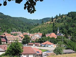
 View of Colroy-la-Roche |
||
Colroy-la-Roche ( German Kolrein ) is a French commune with 488 inhabitants (as of January 1, 2017) in the Vosges in the Bas-Rhin department in the Grand Est region (until 2015 Alsace ). The departmental road D424 connects the village with Ranrupt and Saint-Blaise-la-Roche . The Forêt Domaniale du Champ du Feu is located between Colroy-la-Roche and Ranrupt .
history
In the years 607 and 608 the village was called "Collerinse" and in the 17th century "La colline du roy". After the Thirty Years' War , Colroy-la-Roche was repopulated mainly by immigrants from Switzerland and the Montbéliard region . In 1790 the village was assigned to the canton of Saales and thus to Alsace .
Population development
| year | 1962 | 1968 | 1975 | 1982 | 1990 | 1999 | 2005 | 2013 |
| Residents | 245 | 274 | 307 | 431 | 435 | 455 | 458 | 490 |
coat of arms
Description : Divided into silver and red. Above a red shuttle and below a right-open golden crook of a crook .
Attractions
- In Colroy-la-Roche there are houses that are typical of the upper Bruche valley .
- Saint Nicolas Church
- A discarded wagon stands as a memorial in the village square.

Personalities
- Jean-Baptiste Claudel CSsR (1876–1955), religious, Vicar Apostolic of Reyes in Bolivia
literature
- Le Patrimoine des Communes du Bas-Rhin. Flohic Editions, Volume 2, Charenton-le-Pont 1999, ISBN 2-84234-055-8 , pp. 1042-1044.
