
Lay (Loire)
| Lay | ||
|---|---|---|
.svg)
|
|
|
| region | Auvergne-Rhône-Alpes | |
| Department | Loire | |
| Arrondissement | Roanne | |
| Canton | Le Coteau | |
| Community association | Pays Entre Loire et Rhône | |
| Coordinates | 45 ° 57 ' N , 4 ° 13' E | |
| height | 339-592 m | |
| surface | 12.85 km 2 | |
| Residents | 745 (January 1, 2017) | |
| Population density | 58 inhabitants / km 2 | |
| Post Code | 42470 | |
| INSEE code | 42118 | |
 Look at Lay |
||

Lay is a French municipality with 745 inhabitants (as of January 1 2017) in the department of Loire in the region Auvergne Rhône-Alpes . The municipality belongs to the Arrondissement of Roanne and the canton of Le Coteau (until 2015: canton of Saint-Symphorien-de-Lay ).
geography
Lay is about 15 kilometers southeast of Roanne . Lay is surrounded by the neighboring communities of Régny in the north, Amplepuis in the east and northeast, Fourneaux in the east and southeast and Saint-Symphorien-de-Lay in the south and west.
Population development
| 1962 | 1968 | 1975 | 1982 | 1990 | 1999 | 2006 | 2013 |
|---|---|---|---|---|---|---|---|
| 597 | 644 | 616 | 616 | 687 | 648 | 689 | 722 |
| Source: Cassini and INSEE | |||||||
Attractions
- Notre-Dame chapel, built 1838–1842
- La Verpillière Castle
- Butter Tower (Tour de Beurre), part of the old fortifications
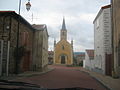
Notre-Dame chapel

Butter tower


Web links
Commons : Lay - collection of pictures, videos and audio files