
Saint-Nizier-sous-Charlieu
| Saint-Nizier-sous-Charlieu | ||
|---|---|---|
|
||
| region | Auvergne-Rhône-Alpes | |
| Department | Loire | |
| Arrondissement | Roanne | |
| Canton | Charlieu | |
| Community association | Charlieu-Belmont Community | |
| Coordinates | 46 ° 9 ' N , 4 ° 7' E | |
| height | 252-408 m | |
| surface | 12.83 km 2 | |
| Residents | 1,702 (January 1, 2017) | |
| Population density | 133 inhabitants / km 2 | |
| Post Code | 42190 | |
| INSEE code | 42267 | |
| Website | http://www.st-nizier-sous-charlieu.fr/ | |
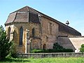
 Saint-Nizier church and town hall (Mairie) of Saint-Nizier-sous-Charlieu |
||

Saint-Nizier-sous-Charlieu is a French commune with 1,702 inhabitants (as of January 1 2017) in the department of Loire in the region Auvergne Rhône-Alpes . It belongs to the Arrondissement of Roanne and the Canton of Charlieu .
geography

Saint-Nizier-sous-Charlieu is about 13 kilometers north-northeast of Roanne am Forez . The Loire limits the municipality to the west. Saint-Nizier-sous-Charlieu is surrounded by the neighboring communities of Saint-Pierre-la-Nouille in the north, Saint-Bonnet-de-Cray in the northeast, Charlieu in the east, Pouilly-sous-Charlieu in the south and Briennon in the west.
Population development
| year | 1962 | 1968 | 1975 | 1982 | 1990 | 1999 | 2006 | 2012 |
| Residents | 1,031 | 1,056 | 1,216 | 1,449 | 1,579 | 1,571 | 1,631 | 1,679 |
| Source: Cassini and INSEE | ||||||||
Attractions
- Saint-Nizier church, rebuilt in 1883
- Cordeliers Convention
- Le Mont Castle
- Rongefer Castle
- Carillon Castle
- Beauvernay Castle

Saint-Nizier church
Corderliers' convent church

Le Mont Castle

Rongefer Castle


Personalities
- Roger de La Fresnaye (1885–1925), painter (Cubism), had his studio in Beauvernay Castle
- Théodore-Gérard Hanssen (1885–1957), glass painter (painted the windows of the Saint-Nizier church)
Web links
Commons : Saint-Nizier-sous-Charlieu - Collection of images, videos and audio files