
Saint-Denis-de-Cabanne
| Saint-Denis-de-Cabanne | ||
|---|---|---|
.svg)
|
|
|
| region | Auvergne-Rhône-Alpes | |
| Department | Loire | |
| Arrondissement | Roanne | |
| Canton | Charlieu | |
| Community association | Charlieu-Belmont Community | |
| Coordinates | 46 ° 11 ' N , 4 ° 13' E | |
| height | 273-423 m | |
| surface | 7.65 km 2 | |
| Residents | 1,251 (January 1, 2017) | |
| Population density | 164 inhabitants / km 2 | |
| Post Code | 42750 | |
| INSEE code | 42215 | |
| Website | http://www.saintdenisdecabanne.fr/ | |
_mairie.JPG) Town hall (Mairie) of Saint-Denis-de-Cabanne |
||

Saint-Denis-de-Cabanne is a French commune with 1,251 inhabitants (as of January 1 2017) in the department of Loire in the region Auvergne Rhône-Alpes . The municipality belongs to the Arrondissement of Roanne and the canton of Charlieu .
geography
Saint-Denis-de-Cabanne is located about 18 kilometers northeast of Roanne on the Sornin and its tributary Botoret . Saint-Denis-de-Cabanne is surrounded by the neighboring communities of Saint-Edmond in the north, Saint-Martin-de-Lixy in the northeast, Maizilly in the east, Mars in the southeast, Chandon in the south, Charlieu in the west and southwest and Saint-Bonnet- de-Cray in the northwest.
Population development
| year | 1962 | 1968 | 1975 | 1982 | 1990 | 1999 | 2006 | 2013 |
| Residents | 1,320 | 1,413 | 1,431 | 1,416 | 1,357 | 1,293 | 1,305 | 1,284 |
| Source: Cassini and INSEE | ||||||||
Attractions
- church
- Gatellier Castle from the 17th century
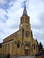
church

Gatellier Castle
_%C3%A9glise.JPG)
_ch%C3%A2teau_de_Gatellier.JPG)
Web links
Commons : Saint-Denis-de-Cabanne - Collection of images, videos and audio files