
Saint-Marcel-de-Félines
| Saint-Marcel-de-Félines | ||
|---|---|---|
|
||
| region | Auvergne-Rhône-Alpes | |
| Department | Loire | |
| Arrondissement | Roanne | |
| Canton | Le Coteau | |
| Community association | Forez-Est | |
| Coordinates | 45 ° 52 ' N , 4 ° 12' E | |
| height | 311-524 m | |
| surface | 22.43 km 2 | |
| Residents | 809 (January 1, 2017) | |
| Population density | 36 inhabitants / km 2 | |
| Post Code | 42122 | |
| INSEE code | 42254 | |

Saint-Marcel-de-Félines is a French municipality with 809 inhabitants (as of January 1 2017) in the department of Loire in the region Auvergne Rhône-Alpes . The municipality belongs to the Arrondissement of Roanne and the canton of Le Coteau (until 2015: canton of Néronde ).
geography
Saint-Marcel-de-Félines is located about 45 kilometers west-northwest of Lyon . The Loire limits the municipality to the west. Saint-Marcel-de-Félines is surrounded by the neighboring communities of Neulise in the north, Saint-Just-la-Pendue in the east and northeast, Néronde in the southeast, Balbigny in the south, Saint-Georges-de-Baroille in the west and Pinay in the northwest.
The A89 car route runs along the southern edge of the municipality , which intersects with Route nationale 82 here .
Population development
| year | 1962 | 1968 | 1975 | 1982 | 1990 | 1999 | 2006 | 2013 |
| Residents | 657 | 667 | 603 | 608 | 700 | 691 | 747 | 818 |
| Source: Cassini and INSEE | ||||||||
Attractions
- Castle from the 11th century, converted into a chateau in the 16th and 17th centuries
- Saint-Marcel church
- Chapel "Grotte de Félines"
- Saint Roch chapel
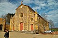
Saint-Marcel church

lock


Personalities
- Pascal Clément (1945–2020), politician (UMP), Minister of Justice (2005–2007), Mayor of Saint-Marcel-de-Félines from 1977 to 2001