Perreux (Loire)
| Perreux | ||
|---|---|---|

|
|
|
| region | Auvergne-Rhône-Alpes | |
| Department | Loire | |
| Arrondissement | Roanne | |
| Canton | Le Coteau | |
| Community association | Roannais agglomeration | |
| Coordinates | 46 ° 2 ' N , 4 ° 7' E | |
| height | 255-436 m | |
| surface | 41.35 km 2 | |
| Residents | 2,114 (January 1, 2017) | |
| Population density | 51 inhabitants / km 2 | |
| Post Code | 42120 | |
| INSEE code | 42170 | |
| Website | http://www.perreux.fr/ | |
Perreux is a French commune with 2,114 inhabitants (as of January 1 2017) in the department of Loire in the region Auvergne Rhône-Alpes . It belongs to the Arrondissement of Roanne in the canton of Le Coteau . Perreux is a member of the Association of Municipalities Roanne Agglomération . The inhabitants are called Pariodins .
geography
Perreux is about five kilometers east of Roanne . The Rhins flows into the Loire at the western municipal boundary . Other rivers that cross the municipality are the Rhodon and its tributary Chambut , as well as the Trambouzan . Perreux is surrounded by the neighboring communities of Vougy in the north, Coutouvre in the northeast, Montagny in the east, Pradines in the southeast, Notre-Dame-de-Boisset and Saint-Vincent-de-Boisset in the south, Le Coteau in the west and southwest, and Roanne in the west and northwest.
history
At the end of the 11th century, Bishop Hugo von Châteauneuf donated the area to the Benedictines of the Cluny monastery. The municipality of Perreux has existed since 1793.
Population development
| year | 1886 | 1936 | 1946 | 1962 | 1968 | 1975 | 1982 | 1990 | 1999 | 2006 | 2012 |
| Residents | 2,481 | 1,513 | 1,651 | 1,728 | 1,907 | 1,885 | 1.933 | 1,985 | 2,075 | 2.167 | 2.212 |
Attractions
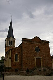
- Saint-Bonnet church from the 14th and 16th centuries
Web links
Individual evidence
- ↑ Perreux on cassini.ehess.fr (French)

