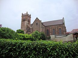
Saint-Cyr-de-Favieres
| Saint-Cyr-de-Favieres | ||
|---|---|---|

|
|
|
| region | Auvergne-Rhône-Alpes | |
| Department | Loire | |
| Arrondissement | Roanne | |
| Canton | Le Coteau | |
| Community association | Pays Entre Loire et Rhône | |
| Coordinates | 45 ° 58 ′ N , 4 ° 6 ′ E | |
| height | 287-541 m | |
| surface | 14.11 km 2 | |
| Residents | 917 (January 1, 2017) | |
| Population density | 65 inhabitants / km 2 | |
| Post Code | 42590 | |
| INSEE code | 42212 | |
Saint-Cyr-de-Favières is a French municipality with 917 inhabitants (as of January 1 2017) in the department of Loire in the region Auvergne Rhône-Alpes . The municipality belongs to the Arrondissement of Roanne and the canton of Le Coteau (until 2015: canton of Saint-Symphorien-de-Lay ).
geography
Saint-Cyr-de-Favières is located about seven kilometers south-southeast of Roanne on the Gand River . Saint-Cyr-de-Favières is surrounded by the neighboring communities of Parigny in the north, Notre-Dame-de-Bosset in the northeast, Neaux in the east, Vendranges in the east and southeast, Saint-Priest-la-Roche in the south, Cordelle in the west and Southwest and Commelle-Vernay in the northwest.
Route nationale 7 runs along the eastern edge of the municipality .
The community owned a train station on the Moret-Veneux-les-Sablons-Lyon-Perrache railway line, which is no longer served today.
Population development
| 1962 | 1968 | 1975 | 1982 | 1990 | 1999 | 2006 | 2013 |
|---|---|---|---|---|---|---|---|
| 481 | 480 | 547 | 696 | 710 | 773 | 802 | 815 |
| Source: Cassini and INSEE | |||||||
Attractions
- Saint-Cyr church from the 19th century
- Rectory from 1636
- Town hall from the 18th century
- Villon Castle

