
Saint-Forgeux-Lespinasse
| Saint-Forgeux-Lespinasse | ||
|---|---|---|
.svg)
|
|
|
| region | Auvergne-Rhône-Alpes | |
| Department | Loire | |
| Arrondissement | Roanne | |
| Canton | Renaison | |
| Community association | Roannais agglomeration | |
| Coordinates | 46 ° 7 ' N , 3 ° 56' E | |
| height | 287-363 m | |
| surface | 16.19 km 2 | |
| Residents | 646 (January 1, 2017) | |
| Population density | 40 inhabitants / km 2 | |
| Post Code | 42640 | |
| INSEE code | 42220 | |
| Website | http://www.saint-forgeux-lespinasse.fr/ | |

Saint-Forgeux-Lespinasse is a French municipality with 646 inhabitants (at January 1, 2017) in the department of Loire in the region Auvergne Rhône-Alpes (before 2016 Rhône-Alpes ). It belongs to the Arrondissement of Roanne and the canton of Renaison (until 2015 La Pacaudière ). The inhabitants are called Ferréolois .
geography
Saint-Forgeux-Lespinasse is located around seventeen kilometers northwest of Roanne in the Côte Roannaise wine-growing region , which stretches along the slopes of the Monts de la Madeleine mountain range and the Tey sun . Saint-Forgeux-Lespinasse is surrounded by the neighboring communities of Changy in the north and west, Vivans in the north, Noailly in the east, Saint-Germain-Lespinasse in the south and south-east and Ambierle in the south and south-west.
The National Route 7 runs through the municipality .
Population development
| year | 1962 | 1968 | 1975 | 1982 | 1990 | 1999 | 2008 | 2013 |
| Residents | 468 | 437 | 385 | 404 | 416 | 416 | 477 | 586 |
| Source: Cassini and INSEE | ||||||||
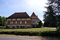
Attractions
- 14th century church
- Lespinasse Castle
- Donjon from the 12th century

church
lock
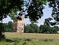
Donjon


