
Saint-André-d'Apchon
| Saint-André-d'Apchon | ||
|---|---|---|
.svg)
|
|
|
| region | Auvergne-Rhône-Alpes | |
| Department | Loire | |
| Arrondissement | Roanne | |
| Canton | Renaison | |
| Community association | Roannais agglomeration | |
| Coordinates | 46 ° 2 ′ N , 3 ° 56 ′ E | |
| height | 327-808 m | |
| surface | 13.44 km 2 | |
| Residents | 1,946 (January 1, 2017) | |
| Population density | 145 inhabitants / km 2 | |
| Post Code | 42370 | |
| INSEE code | 42199 | |
| Website | http://www.saint-andre-d-apchon.fr/ | |

Saint-André-d'Apchon is a French commune with 1,946 inhabitants (as of January 1 2017) in the department of Loire in the region Auvergne Rhône-Alpes . Saint-André-d'Apchon belongs to the Arrondissement of Roanne and the canton of Renaison (until 2015: canton of Saint-Haon-le-Châtel ).
geography
Saint-André-d'Apchon is about ten kilometers west of Roanne on the Forez . Here in the vineyards is the Côte Roannaise wine-growing region . Saint-André-d'Apchon is surrounded by the neighboring communities of Renaison in the north and north-west, Pouilly-les-Nonains in the east, Ouches in the south-east, Saint-Alban-des-Eaux in the south and Arcon in the west and south-west.
Population development
| year | 1962 | 1968 | 1975 | 1982 | 1990 | 1999 | 2006 | 2012 |
| Residents | 1,094 | 1,154 | 1,347 | 1,699 | 1,720 | 1,741 | 1,843 | 1.917 |
| Source: Cassini and INSEE | ||||||||
Attractions
- Church of Saint-André, Monument historique
- Renaissance castle, Monument historique
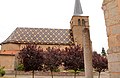
Church of Saint-André

Renaissance castle of Saint-André-d'Apchon


Community partnerships
A partnership has existed with the German municipality of Wittnau in Baden-Württemberg since 1994.